


We invite your feedback and contributions to this article. Please view the maps by clicking the link at the end of the article.
Representing or portraying information through visual means such as via maps is known to be an efficient way of communication and holds great potential for connecting science with decision-making. In conservation, spatial maps and information are crucial tools for understanding socio-ecological processes and patterns, identifying threats and extent of impacts, prioritising actions/places and planning.
Mapping freshwater ecosystems
For freshwater ecosystem management, representing information spatially through maps is particularly relevant given their interconnected nature and they being sinks in the landscape. When conservation efforts are conducted at relatively large scales (e.g watershed, basin), mapping patterns in integrity of freshwater ecosystems across space are a useful tool to allocate and prioritise conservation resources, and to inform planning for monitoring, and ecosystem-based management, ultimately enhancing decision-making about conservation investments. Such information can help determine relationships and links between threats, conservation actions, conservation outcomes, and money invested, which is essential for conservation planning.
Data collection and mapping with a strong, consistent, transparent, repeatable, and science-based protocol is crucial for effectively supporting decision-makers in developing conservation and management plans.
Freshwater ecosystems are often underrepresented in land-use and conservation planning efforts in India, where limited information regarding the distribution, condition and status of these ecosystems is one of the contributing factors.
In March 2022, a workshop to draft the conservation vision for freshwater ecosystems in India, organised by The Nature Conservancy (TNC), India, The Foundation for Ecological Security (FES) and Ooloi Labs, brought out several challenges in freshwater conservation, with limited data generation and understanding around freshwater ecosystems being one of them.
Here, we aim to contribute to addressing this challenge by providing information on the spatial distribution of different biophysical typologies, condition/integrity, status and extent of enabling conditions for watersheds across India.
Categorising Indian watersheds
Freshwater management and conservation planning efforts are often conducted at watershed scales. A watershed (analogous to “catchment”, “drainage basin”) comprises a set of physical, chemical and biological elements connected by the flow of water and are hierarchically organised in space (spatially nested; think Russian dolls).
Capturing and representing information at these scales ensures the inclusion of different freshwater ecosystems (such as rivers, wetlands, groundwater), connectivity, hydrological processes and provides the spatial context for conservation decisions.
Hence, the information presented here was collated/consolidated at hierarchical watershed scales. For producing these maps, we used datasets that are widely acknowledged and/or from peer reviewed publications (with permission).
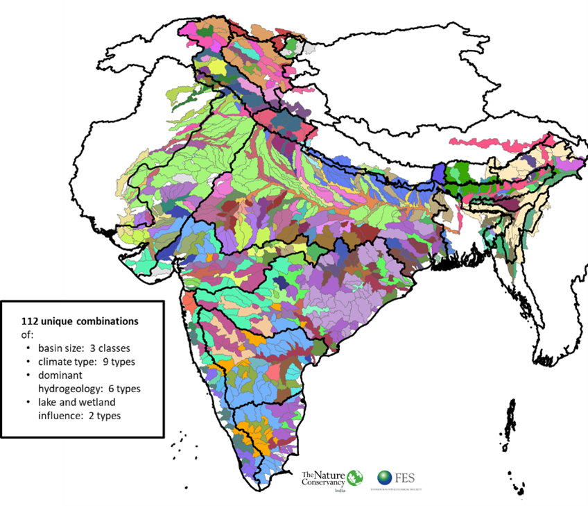
Our watersheds are diverse
We classified the watersheds based on basin size, temperature, climatic moisture, wetland influence, and hydrogeological typology to capture the patterns/diversity in climate, drainage and physiography which influence characteristics such as morphology and hydrological, temperature and nutrient regimes, which in turn influence biodiversity/ecological patterns. Freshwater biodiversity information was not used here as there is a lack of relevant and consistent data at a national scale.
Watersheds in India seem to be highly diverse- there are about 112 types of watersheds indicating a high level of diversity in characteristics. Looking within the different Freshwater Ecoregions, the Ganga delta and Plain ecoregion has a high watershed diversity, followed by Upper and Lower Indus and Northern Deccan Plateau.
Watershed diversity likely drives and indicates diversity in freshwater species, habitats, ecosystem processes and services. To assess the efficacy of this classification in capturing patterns in freshwater diversity and ecosystem services, wide-scale data generation on these parameters would be needed, which is currently lacking.
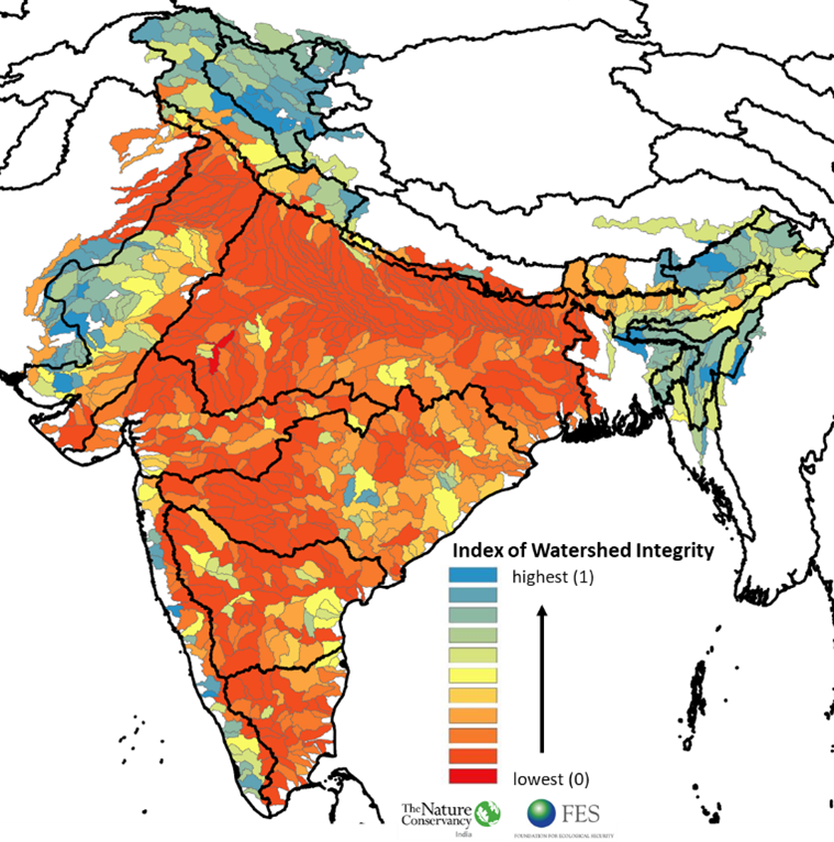
Most watersheds have relatively poor integrity
Recently, Flotemersch et al (2016) developed an Index of Watershed Integrity (IWI) which is defined as the capacity of a watershed to support and maintain the full range of ecological processes and functions essential to the sustainability of biodiversity and of the watershed resources and services provided to society.
The overall integrity of the watershed is scaled between 0 and 1, making it a comparative tool for watersheds. We implemented this method to assess the integrity of Indian watersheds using datasets representing surface and groundwater pollution, agricultural water scarcity, drought occurrence, connectivity status and land use types.
About 69 percent of watersheds in India have relatively low watershed integrity (<0.3). Those with relatively higher integrity lie in the Upper Indus, Upper/Middle Brahmaputra and Western Ghats ecoregions. A low index of watershed integrity indicates a greater degree of impairment of one or more watershed functions (viz. hydrologic regulation, regulation of water chemistry, sediment regulation, hydrologic connectivity, temperature regulation and habitat provision).
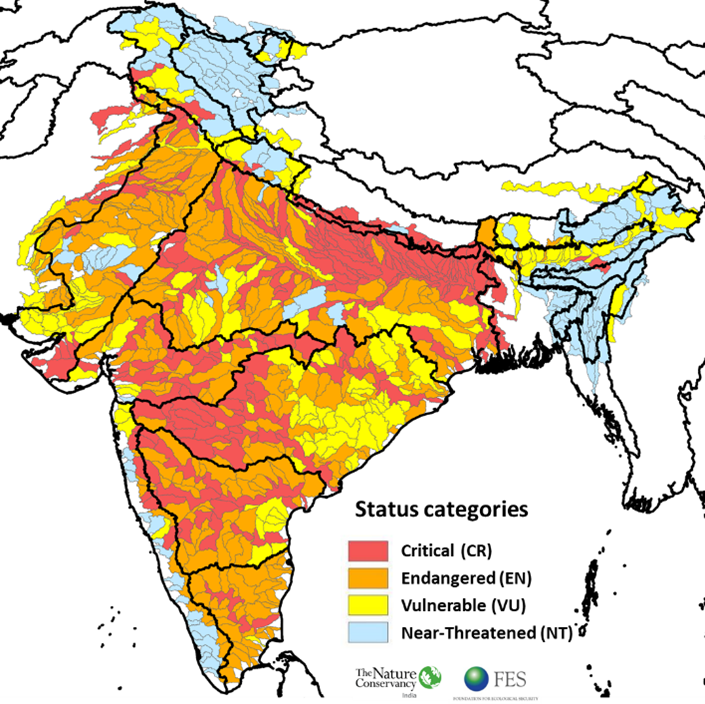
Most watersheds are either critical or endangered
We combined the information from biophysical classification and index of watershed integrity and used thresholds to assign four status categories to watersheds: Critical, Endangered, Vulnerable and Near-threatened. These categories capture the extent/proportion of each watershed type with different levels of watershed integrity, where the Critical category signifies watershed types with a high proportion of poor integrity while the Near-threatened category signifies watershed types with a high proportion of relatively better/good integrity.
Based on this assessment, about 61 percent of our watersheds are either Critical or Endangered which corresponds to observations on the generally deteriorating condition of our rivers, wetlands and groundwaters.
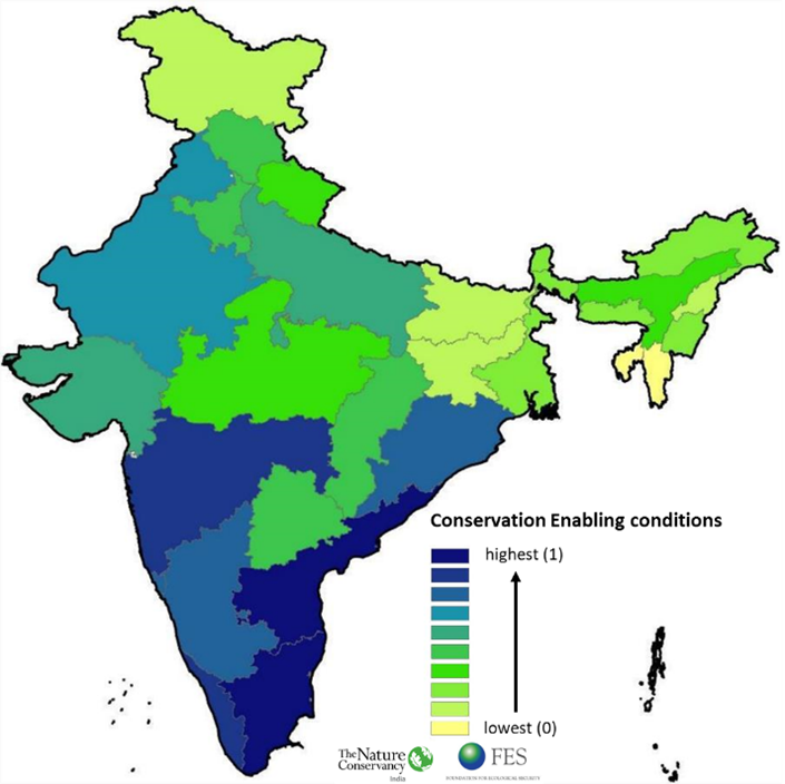
The conservation enabling environment across the country varies
Enabling conditions are factors that increase the likelihood of an intended change/implementation action or strategy. These include factors such as funding, community support, political will, andsuitable governance framework. We tried to capture three critical factors namely, presence of favorable governance framework, financial resources and ongoing conservation activities/community engagement (an indicator of political will and community support), to broadly capture the extent of enabling conditions for freshwater ecosystem conservation across states in India.
This assessment showed that enabling conditions are not constant across the country, with states in the south having a relatively better enabling environment for freshwater conservation. However there is a paucity of datasets that can help differentiate the states in terms of the enabling conditions in a more nuanced way.
Way forward
These maps can have broad applications for planners, which could make use of such maps as a first step for defining/prioritising conservation and management actions at broad scale and basin/watershed scale vision statements.
For instance, the status map highlights that given different states of watersheds, the solutions and actions to manage and conserve them will need to be tailored accordingly, i.e. there is no “silver bullet” solution to conserving freshwater ecosystems.
Similarly, the enabling conditions map highlights that greater efforts might be needed to strengthen these conditions in some regions compared to the rest. The biophysical classification map highlights that there is high diversity in watersheds, indicating a similar trend in freshwater biodiversity, habitats and ecosystem functions, something that may not have been apparent for many regions (given paucity of data).
While these maps provide useful information on spatial patterns in watershed types, integrity, status and enabling conditions, they capture these patterns at broad scales.
- For further actions at finer scales, target freshwater ecosystems should be subjected to more detailed evaluations in order to have site-level measurements of the integrity and local stressors. Capturing fine scale patterns will require data at those scales, which are not available more often than not, highlighting the need to bring a greater focus on freshwater ecosystems and for transitioning towards a data rich environment.
- These maps, even though at a broader scale, are still very relevant as the nation prepares its next water policy and can help aid states prioritise watersheds in planning for ecosystem-based adaptation interventions/plans for water security for the localities that have become vital in times of contested claims and climate-risked situations.
- These maps could also serve as a tool for the civil society/academia/community organizations/corporations to prioritise regions/watersheds for conservation planning, freshwater conservation research, ecosystem management or contribute to developing their own strategies for watershed management. For instance, we used these maps (in conjunction with assessing enabling conditions applicable to our organisations) to select a watershed for freshwater conservation planning.
The intent is to keep these outputs dynamic and adaptive wherein data, tools, maps, and models could be iteratively updated and refined with new developments and data as and when available.
We would like to invite all the readers to go through these maps and methods for feedback and contribute to improving them.
To explore these maps further, please have a look at the web-app. For any questions pertaining to the maps and to get more information regarding the methodology/datasets used, please reach out to Dr Roshni Arora (roshni.arora@tnc.org )


