


Himalaya is one of the youngest mountain systems on Earth, and has a direct influence on the climate, hydrology and environment of the Indian subcontinent. It is the abode of one of the world’s largest and mostly inaccessible area of glaciers outside the polar region and provides glacier-stored water to the major Indian river basins. Many of the Himalayan rivers are fed by snow and ice melt run-off from snow fields and glaciers.
Glacier inventory carried out by the Geological Survey of India (GSI) indicates the existence of over 9000 glaciers in the Indian administered part of the Himalaya. Globally, glaciers are considered to be the sensors of climate change. Any small disparity in the climate will affect the accumulation and ablation rate of glaciers, which in turn affects mass balance of the glaciers.
Observations showed that the 20th century was a period of glacier retreat in almost all alpine regions of the world with accelerated glacier ice and snow melting in the past two decades. Various studies suggest that many of the Himalayan glaciers have receded in recent decades due to climate forcing. The Intergovernmental Panel on Climate Change (IPCC) considered the mountain glacier as the top priority climatic indicator due to the sensitivity of glaciers to climate.
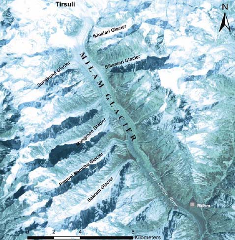
Milam Glacier in Kumaon Himalaya
The lack of in situ meteorological data in many parts of the Indian Himalayan terrain limits better understanding of such environmental changes measured from space. Accurate determination of these glacier changes may be useful in assessing regional hydrological responses in Indian rivers. The retreat of glaciers in the Himalaya has significant impact on the environment, including freshwater supply, diminishing wetlands and unstable stream runoff.
This study uses satellite remote sensing which has been proven to be the best tool in the field of glaciology, because many of the glaciers are located at very high altitude, cold weather and rugged terrain conditions, making it a tedious, hazardous and time-consuming task to monitor by conventional field methods.
Temporal satellite data analysis shows that the Milam Glacier in Goriganga Basin, Kumaon Himalaya receded laterally 1328 ± 40 m with a variable annual rate of 25 m and vertically 90 ± 33 m between 1954 and 2006. The space imagery was used to reconstruct the palaeoextent of the Milam Glacier to 2.4 km downstream of the present terminus position. The study shows that repetitive space-borne optical data can be used to obtain glacier dynamics of inaccessible terrains of the Indian Himalaya.
The approach presented here opens new perspectives for observing and understanding spatio-temporal variability of glaciers in the Himalayan terrain using satellite data.
Download the report here -
 Recession_and_reconstruction_of_Milam_Glacier_in_Kumaon_Himalaya_Current_Science_2011.pdf


