


Climate change and anthropogenic activities pose serious threats to river basin hydrology worldwide. The Ganga River is the lifeline for close to half a billion people in the northern Indian region. During the twentieth century, the hydrology of the basin has been significantly modified owing to increasing anthropogenic interventions and changing climatic conditions.
The increasing high-intensity rainfall events often create flash flooding events. Such events are frequently reported in mountainous and alluvial plains of the Ganga basin, putting the entire basin under severe flood risk. Further, increasing human interventions through hydraulic structures in the upstream reaches significantly alter the flows during the pre-and post-monsoon periods.
The Ganga River basin is regulated by more than 300 hydraulic structures (planned, commissioned and under construction) to harness the hydropower and cater for agricultural water demands. As a result, the upstream–downstream linkages of hydrological, geomorphological and ecological processes in the Himalayan River basins are severely impacted.
Therefore, river practitioners and scientists need to understand the implications of hydrological modifications caused by changing climate and anthropogenic activities. A recent study ‘Modified hydrologic regime of Upper Ganga basin induced by natural and anthropogenic stressors’ published in the journal Scientific Reports has assessed the role of changing climatic conditions and increasing human activities on stream flows in the Upper Ganga Basin.
The available hydrological dataset at different gauging stations was used to perform the hydrological analysis for pre-and post-dam conditions in the Upper Ganga Basin. The changing magnitudes of flows at those locations where large hydraulic structures were built before 1995 in the Upper Ganga Basin was estimated.
The hydrological changes owing to changing climatic conditions and operations of hydraulic structures were investigated. The study assessed how these upstream hydrological modifications altered the hydrological regimes of the downstream regions of the Upper Ganga Basin.
The daily rainfall, discharge, and suspended sediment datasets were divided into two periods - (1) 1971–1994 (pre-1995), and (2) 1995–2010 (post-1995). This temporal division was done based on the fact that the construction of a large hydraulic structure, i.e., Tehri dam (total capacity 4000 million cubic meters), started in 1995 in the Bhagirathi basin, and the frequency of flash flooding events increased in the Upper Ganga Basin after 1995.
Hence, the anthropogenic and climate-induced alterations in the hydrology of the Upper Ganga Basin could be captured by comparing the pre-1995 and post-1995 flow duration curves and sediment duration curves.
Increasing anthropogenic activities and their future impacts
Results indicate that low and moderate flows have been significantly altered, and the flood peaks have been attenuated by the operation of hydraulic structures in the Bhagirathi (western subbasin). The Alaknanda (eastern subbasin) has experienced an increase in extreme rainfall and flows post-1995.
The downstream reaches experience reservoir-induced moderate flow alterations during pre-and post-monsoon and increasing extreme flood magnitudes during monsoon. Furthermore, substantial siltation upstream of the reservoirs has disrupted the upstream–downstream geomorphologic linkages.
Overall, these hydrological analyses indicate that the flow in the Bhagirathi basin has been anthropogenically modified owing to the presence of several large and small dams. In particular, low and moderate flows, which occur primarily during pre- (Jan-May) and post-monsoon (Oct-Dec) periods, are significantly impacted. The Alaknanda was a free-flowing river before the Srinagar dam was commissioned in 2015, followed by the Tapovan dam in 2020.
However, the data records could not capture these hydrological alterations at Joshimath and Rudraprayag in the Alaknanda. Recent hydrological records can be further used to verify these hydrological changes.
The study demonstrates that the present low and moderate flows coming out from Devprayag and Rishikesh (downstream of the Upper Ganga Basin) are entirely modified anthropogenically. The interventions have severely affected the upstream and downstream hydrology and geomorphology of the Bhagirathi basin.
The Upper Ganga Basin has witnessed modifications in the flow regime owing to several small and large hydraulic structures, particularly in the Bhagirathi basin (western tributary). In contrast, the Alaknanda basin (eastern tributary) has experienced increasing magnitudes of extreme rainfall events from 1970 to 2019.
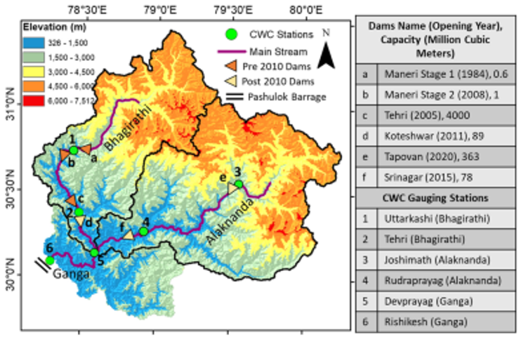
The flow modifications in these basins have been influenced by different factors. Results suggest that the reduction in rainfall magnitudes, Maneri dam in upstream and Tehri dam in downstream exert primary controls on the flows in the Bhagirathi. As a result, low and moderate flows increased at Tehri by 125%. In addition, the post-1995 extreme flows at different return periods have decreased by 21.3% in the Bhagirathi basin.
Further, the Alaknanda basin was a free-flowing river until 2015. The extreme flows at different return periods have increased by 8–15% in the Alaknanda basin, primarily because of increasing high-intensity rainfall events post-1995.
Therefore, the Alaknanda basin has witnessed some extreme flash flood events in recent years. Simultaneously, the downstream reaches experience anthropogenically modified low and moderate flows that are attributed to Tehri and other dams during pre-and post-monsoon months.
The results further indicate that a significant amount of sediments transported during high flows are trapped in the Tehri and Maneri reservoirs in the Bhagirathi basin. Therefore, hydraulic structures have significantly disrupted the upstream–downstream geomorphologic linkages, thereby impacting the channel morphology in the downstream reaches as observed in several regions.
Furthermore, several hydraulic structures such as the Pashulok barrage were designed based on analysis of past extreme floods. However, the increasing magnitude of extreme flows (10-20%), particularly at Devprayag, might also affect the functioning of the Pashulok barrage during peak monsoon periods. The downstream regions also experience reservoir-induced flow increments during pre-and post-monsoonal months.
Around 11 and 26 additional dams of different power generation capacities in the Bhagirathi and Alaknanda basin, respectively, are planned. These planned hydraulic structures will be located on several small and large tributaries of the Upper Ganga Basin.
These structures are likely to impact the low and moderate flows of the Upper Ganga Basin further, as demonstrated in the case of the Bhagirathi basin. Additionally, the increasing number of dams will also influence the sediment transport processes across the Upper Ganga Basin.
Overall, the results obtained from this work should help in sustainable river basin management and encourage more serious work toward a better understanding of hydrology, ecology, and geomorphology in the Upper Ganga Basin.


