- Topics
- Feature
- Opportunities & Events
- About
- Hindi Portal
- Data
- Topics
- Feature
- Opportunities & Events
- About
- Hindi Portal
- Data
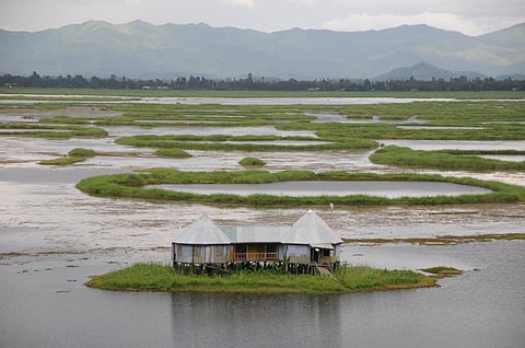
Sharada Prasad C S, Flickr Commons

Some landscapes do not collapse. They adjust, absorb, and rearrange themselves quietly, escaping immediate attention. The most consequential environmental changes often unfold slowly. They become visible only over time, in patterns that are easy to miss on the ground.
Satellite images tell that longer story. Over decades, they reveal water spreading where vegetation once held, settlements moving inward, and floating life breaking apart. Seen this way, Loktak is not just a lake under pressure. It is a system in transition, steadily being rewritten.
For decades, the transformation of Loktak Lake has unfolded quietly, almost imperceptibly to those who live along its shores. The lake still looks vast. Fishing boats still move through its waters. Floating islands still dot its surface. Yet beneath this apparent continuity, the structure of the lake has been steadily rewritten. A detailed geospatial study spanning nearly four decades now makes visible what has long been sensed but rarely quantified: Loktak is not merely degrading—it is being reorganised by human intervention.
Using satellite imagery from 1977 and 2015, researchers Kangabam, Selvaraj, and Govindaraju tracked changes in land use and land cover across the lake. Their findings were published in The Egyptian Journal of Remote Sensing and Space Sciences and reveal profound shifts in the balance between water, vegetation, agriculture, and settlement—changes that collectively threaten the ecological logic on which the lake depends.
Reading a lake through satellites
Remote sensing uses satellite images to study landscapes over time. Instead of looking at a place as a single moment, it helps us understand how different parts of a system change and interact. In Loktak, researchers divided the lake into five types of areas. These include open water, agricultural land, settlements, and two kinds of phumdis.
Phumdis are floating masses made of vegetation, soil, and organic matter. Some are thick and well established, while others are thinner and often newer or still regenerating. These categories help explain how the lake functions. They show how water, floating vegetation, and human activity are spread across the lake and how they influence each other.
The satellite data shows clear changes between 1977 and 2015. Open water increased a lot. Agricultural areas grew to more than three times their earlier size. Settlements in and around the lake also expanded rapidly. At the same time, phumdis declined sharply. The thinner ones, which are important for regeneration, saw the biggest drop.
Note: Visualizing the transition from a complex biological network to a simplified reservoir. Note the massive expansion of the central blue zone and the yellow agricultural encroachment.
This is not a case of uniform shrinkage or expansion. It is a redistribution of space, driven by policy choices and livelihood pressures, with ecological consequences that are uneven but cumulative.
At first, the increase in open water may seem surprising, especially when wetlands are usually described as shrinking. But the study shows that this increase is mostly artificial. After the Ithai Barrage was built, large areas of phumdis were removed, especially in the central part of the lake. Phumdis are floating masses of vegetation, soil, and organic matter. They were cleared to keep the water open for hydropower generation and boat movement.
From above, this can look like the lake is recovering. In reality, it is becoming simpler and less functional as an ecosystem. Earlier, open water and phumdis existed together. The phumdis moved hydrology with the seasons. During high water flows, they would drift out and later regenerate. The barrage disrupted this natural cycle. It keeps water levels constant throughout the year.
This prevents phumdis from moving and affects how nutrients and sediments circulate in the lake. Removing phumdis may create more open space, but it does not solve the underlying problem. Instead, it weakens the lake’s ability to renew itself over time.
The Ithai Barrage is the most important human intervention shaping Loktak today. Built for a hydroelectric project, it turned the lake into a controlled reservoir. Earlier, the lake followed natural seasonal patterns of rising and falling water levels. This seasonal movement, known as hydrology, helped maintain ecological processes. The barrage broke this link between water flow and ecosystem function.
As a result, low-lying farmland around the lake was permanently flooded. Farmers lost their land and were pushed to depend more on the lake. Floating agriculture increased as a way to cope. Phumdis, which once supported the ecosystem, began to be used for farming. This change is important. It explains why farming within the lake increased sharply while phumdis declined. The lake ended up absorbing the social and economic impacts of controlling its natural water system.
Livelihood pressure moves inward
Loktak supports more than two lakh people directly or indirectly. Census data cited in the study show rapid population growth in settlements surrounding and within the lake, including villages such as Thanga and Karang. As land outside the lake became less accessible or less productive, dependence on lake resources intensified.
The satellite images confirm this demographic story. Settlement area within the lake more than doubled between 1977 and 2015. This inward movement is not simply encroachment; it reflects the absence of viable alternatives. Fishing, floating agriculture, and resource extraction remain among the few available livelihood options.
Yet as more people depend on the lake, the ecological base that sustains these livelihoods weakens. Nutrient runoff, waste discharge, and physical fragmentation of phumdis accumulate quietly but persistently.
Why the loss of phumdis matters
To understand Loktak, one must understand phumdis. These floating masses of vegetation, soil, and organic matter are not passive features. They regulate water quality, store nutrients, support fisheries, and provide habitat for species found nowhere else.
The study shows that phumdis with thin vegetation declined by nearly 50 square kilometres over the study period, while thick phumdis also shrank substantially. The phumdis are especially important because they represent the regenerative layer of the system. Their loss signals declining resilience.
Nowhere is this more consequential than in the southern zone of the lake, which supports Keibul Lamjao National Park, the world’s only floating national park and the last natural habitat of the endangered Sangai deer. As phumdis thin and fragment, the very ground beneath this ecosystem weakens.
Water quality and invisible degradation
The study mainly looks at changes in land use, but its findings are closely linked to concerns about water quality. Other research mentioned by the authors shows that Loktak’s water is already in poor condition. This is worrying because many communities still depend on it for drinking and daily use.
Changes in how the land is used are making this worse. More agriculture means more fertilisers washing into the lake with rainwater. This is called runoff. Growing settlements add untreated waste. At the same time, fewer phumdis reduce the lake’s ability to naturally clean the water. Phumdis act like filters by trapping nutrients and pollutants.
These changes do not cause immediate visible damage. Instead, water quality declines slowly over time. The risk is that this gradual decline goes unnoticed until a critical limit is crossed and the damage becomes severe. This is the danger of slow change. It often does not trigger timely action.
An important contribution of the study is its use of remote sensing. This means using satellite images taken over many years to track changes. The researchers combined images from different time periods with GIS analysis. GIS, or Geographic Information Systems, is a method used to map and analyse spatial data.
This approach shows how remote sensing can be used for continuous monitoring, not just one-time studies. The maps created in the study are about 86 percent accurate. They clearly show where and how the lake is changing. This kind of information is useful for policy and planning.
However, such tools are not widely used in managing wetlands. Governance often depends on scattered surveys and short-term responses. Loktak shows the cost of this gap. Decisions affecting the entire lake were made without regular spatial monitoring. As a result, gradual changes built up over time without being fully noticed.
What needs to change
The authors call for better land use planning and stronger enforcement of the Manipur Loktak Lake Act, 2006. But the findings suggest that more needs to be done. First, management should move beyond simply clearing phumdis. Instead, it should focus on ecological restoration that works with natural seasonal water cycles, also known as hydrology.
Second, the way the barrage is operated needs to be reviewed. It should consider ecological needs, not just technical or power generation goals. Third, the lake needs clear zoning. This means defining which areas are for conservation, which can be used in a regulated way, and where settlements are allowed. These decisions should be based on spatial data.
The human dimension is equally important. Conservation efforts will not succeed if they ignore livelihoods. Reducing pressure on the lake requires creating alternative income opportunities, improving fisheries systems, and providing services that reduce dependence on the lake. Finally, monitoring using remote sensing should become a regular part of governance. Loktak needs a permanent system to track land use, vegetation, and water changes over time.
A lake at a threshold
Loktak Lake is still alive. Its floating islands have not vanished. Its fisheries still function. But the satellite record leaves little doubt that the system is being pushed beyond its historical operating range.
The lesson from this study is not simply that wetlands are fragile. It is that governance often lags behind landscape change. By the time degradation is visible to the naked eye, it is already embedded in spatial patterns that are difficult to reverse.
Loktak’s future will depend on whether science is allowed to inform policy in time. The satellites have already told the story. The question now is whether decision-makers are willing to read it.
Loktak Lake is not gone. It is still functioning, still supporting life, still holding together. But it is no longer operating on its own terms. The changes mapped over four decades show a system being steadily pushed beyond its natural limits. Not through sudden collapse, but through slow, cumulative shifts in how water, land, and people interact.
The science is no longer the missing piece. The patterns are clear. The drivers are known. What remains uncertain is whether governance can respond at the same scale and speed as the change itself. Because in Loktak, the question is no longer whether the lake is changing. It is whether we are willing to change how we manage it.
Cite paper: Kangabam, R. D., Selvaraj, M., & Govindaraju, M. (2018). “Assessment of land use/land cover changes in Loktak Lake in the Indo-Burma Biodiversity Hotspot using geospatial techniques.”