- Topics
- Feature
- Opportunities & Events
- About
- Hindi Portal
- Data
- Topics
- Feature
- Opportunities & Events
- About
- Hindi Portal
- Data
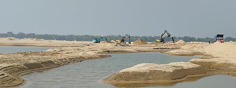
Riverbed sand mining on the Damodar near Nabagram village in West Bengal, showing an influx of JCBs and trucks on the riverbed. The various anthropogeomorphic landforms induced by sand mining are also visible such as, sand mounds, excavated sand pools, and levelled sand tracks created by mining activity.
Priyank Pravin Patel
Rivers, in their quieter seasons, invite attention. As water levels drop, sandbars emerge, channels widen, and the river reveals layers shaped over time. Rivers in West Bengal appear to slow down and open up. Falling water levels expose wide sandbars along the Ajay, Damodar, and Subarnarekha. There is a certain openness to this landscape, a sense that the river is pausing, breathing, and making its history visible.
Look closer, however, and the details begin to feel unfamiliar. Thin, finger-like strands stretch into the water. Some end abruptly, while others branch outward, spreading across exposed sandbars and into the river channel. Between them lie deep hollows where the surface has been scraped away, exposing layers of older sand deposits. Deeper still are large pools, circular to elongated in shape. Some remain connected to the flowing river; others sit carved directly into the sandbar itself. The water in these pools varies. Some appear dark and still. Others take on a yellowish hue, clouded by fine sand particles held in constant suspension.
What initially appears unusual soon reveals itself as unnatural. These forms are not shaped by the river’s flow or by familiar geomorphic processes. Their origin becomes clear when the wider scene comes into view. Long lines of trucks stand parked bumper to bumper along these sandy strands. Nearby, a JCB machine swings and flexes its arm repeatedly, scooping wet sand from the riverbed and depositing it in regular mounds besides waiting vehicles. This is no isolated scene. It is now a familiar sight across West Bengal’s sandy rivers during the dry season. These are human-made landscapes, formed by large-scale sand extraction that is steadily reworking riverbeds. According to a study by the United Nations Environment Programme (UNEP), India is among the top five sand-extracting nations globally, with an estimated annual extraction rate of over 500 million tons.

Riverbed sand mining on the Damodar also showing the temporary bamboo bridge built across the river to enable JCB and truck access to the sandbars. Excavated, piled-up sand mounds are seen in the foreground.
Priyank Pravin Patel
Mining-induced landforms and their ecological impacts
Despite their visibility, systematic documentation of such human-made river features has been limited in India. A recent study funded by the Anusandhan National Research Foundation addresses this gap by closely examining mining-affected stretches of the Ajay, Damodar, and Subarnarekha rivers in West Bengal. It documents how sustained sand extraction is creating new, previously undocumented human-made landforms within river channels and how these changes are affecting river water quality, especially turbidity and suspended sediments.
The study identifies these features as anthropogeomorphic landforms, created through sustained human intervention and now functioning as part of the river’s physical system. Three main processes are involved.
i) Excavation: produces sand hollows and deep pools.
ii) Planation: levels sandbar surfaces to create compacted tracks and temporary bridges for heavy vehicles.
iii) Accumulation: forms sand mounds where excavated material is stored before transport.
Depending on how frequently mining takes place, these features may be seasonal or persist for years. Their extent and spread increase with the intensity of extraction.
From over land and under water – sand extraction from boats that dredge the Ajay River near Illambazar town. The various anthropogeomorphic landforms induced by such sand mining are also visible – sand mounds on the riverbed, sand pools where hollows have been deepened and levelled sand tracks.
Priyank Pravin Patel
Using multi-year satellite images and field surveys, the study tracks how these landforms expand and persist over time. In the Subarnarekha River, where large-scale sand mining intensified after 2020, the number of sand pools increased nearly two and a half times between 2021 and 2022. The total area occupied by these pools almost tripled within two years. Such rapid expansion reflects not isolated extraction, but a systematic reworking of the riverbed.
Sand mining has been ongoing for decades in the Ajay and Damodar. In contrast, mining in the Subarnarekha is more recent, driven by rising demand for construction material as real estate development and urbanisation expand in the region. From 2020 onwards, the rapid growth and spread of sand pools in the Subarnarekha clearly reflect this shift.
The ecological consequences are significant. Water quality in mining pools shows low dissolved oxygen and high turbidity levels, creating inhospitable conditions for aquatic life. The Damodar River, which is the most intensively mined, exhibits the greatest degradation in in-stream habitats. Measurements show suspended sediment concentrations in mined river stretches ranging from 150 to 350 milligrams per litre, far exceeding limits set by the Central Pollution Control Board. Turbidity levels are even higher within isolated sand pools. When these pools dry up or become disconnected from the river, fish trapped within them often die.
Riverbed sand mining on the Ajay at Desher Mohan village in West Bengal, showing the excavated large sand pool, piled-up sand mounds and levelled sand tracks for the JCBs to access the sandbars in the river.
Priyank Pravin Patel
How mining reshapes riverbeds and water quality over time
The burgeoning demand for sand as a construction material has driven widespread riverbed sand mining across the country. In many river stretches, the channel no longer flows as a continuous system. Instead, it is broken into a patchwork of excavated pools, compacted access tracks, and sand mounds.
Although the study focuses on the Ajay, Damodar, and Subarnarekha rivers in West Bengal, the features it documents are not limited to these rivers. Similar signs of sand mining appear in many sand-rich rivers across India. Looking at these places helps place the West Bengal findings in a wider national context.
Along the Kaveri near Tiruchirappalli in Tamil Nadu, satellite images from 2020 to 2023, show two river branches flowing side by side. In the branch where sand mining is active, the riverbed is broken into rectangular pools linked by narrow tracks made for vehicles. The nearby branch, where mining is minimal, still flows as a more continuous channel. The contrast between the two is stark and visible even at a glance.
A similar story unfolds along the Mahanadi near Cuttack in Odisha. Images from recent years show how mining often starts with a few tracks extending from the riverbank onto a sandbar. Over time, these tracks spread outward as sand between them is dug out. Small hollows join to form large pools, and by the end of the mining cycle, most of the sandbar is gone. What remains are faint outlines of the routes once used by trucks.
The colour differences in satellite images tell another part of the story. Mining pools appear dull green or grey, while nearby flowing channels look darker and clearer. This contrast points to constant churning of sediment in the mined areas as sand is repeatedly scooped up. These pools often remain visible for years, even after monsoon floods that might be expected to refill them with fresh sediment.
Together, these examples show that the changes seen in West Bengal are part of a broader pattern. Rising demand for construction sand has led to widespread riverbed mining across India. In many places, rivers no longer flow as single connected systems. Instead, they are reshaped into a patchwork of pools, tracks, and sand piles. The West Bengal study captures this process in detail, but the same transformation is playing out quietly in river after river across the country.
The Kaveri River at Tiruchirapalli demonstrates how sand mining severely changes the channel appearance in one section of the river by segmenting it into numerous hollows, while the un-mined section appears far more natural.
Priyank Pravin Patel
The physical reshaping of riverbeds has direct ecological consequences. Field measurements and satellite-derived estimates show that mining-affected river reaches experience sharply degraded water quality. During peak extraction periods, suspended sediment concentrations range from 150 to 350 milligrams per litre, far exceeding acceptable thresholds for healthy river systems.
Within isolated sand pools, sediment loads are even higher. Constant excavation keeps fine particles in suspension, reducing water clarity and lowering dissolved oxygen levels. These conditions are inhospitable to aquatic organisms. When pools become disconnected from the main channel and eventually dry out, fish trapped within them often die.
Among the rivers studied, the Damodar shows the most severe in-stream habitat degradation, reflecting its long history of intensive sand mining. Similar impacts have been documented in sand and gravel mining-affected rivers across the Himalayan foothills, the Gangetic plains, and peninsular India, suggesting that this is a widespread pattern rather than a local anomaly. Taken together, these observations point to a quiet but far-reaching transformation of river systems, driven not by natural forces, but by sustained human extraction.
Successive stages of sand mining in the Mahanadi River near Cuttack in Odisha from December 2020 to May 2023 have altered the river’s appearance and consumed the sandbar deposit, leaving behind only finger-like projections of sand tracks/roads used by trucks and JCBs.
Priyank Pravin Patel
At first glance, removing sand from a riverbed may seem like a local or temporary intervention. But when mining continues season after season, its effects reach far beyond the excavation site. Rivers begin to behave differently. Their channels shift, their banks weaken, and the delicate balance that keeps water, sediment, and ecosystems connected starts to unravel.
Continual sand mining can substantially transform river behaviour. It alters channel shape, weakens stability thresholds, and accelerates riverbank erosion. As sand is removed, the riverbed deepens through renewed incision, driven by what scientists call the “hungry water effect”, where sediment-starved flows erode the bed and banks more aggressively. In-stream habitats are disrupted, affecting the plants and animals that depend on stable river conditions.
The impacts do not stop within the channel. Changes extend into adjoining floodplains, where agricultural lands are eroded and local groundwater levels decline. This happens as water seeps through the subsurface along steepened hydraulic gradients, moving from higher floodplain aquifers towards the deepened river channel. Over time, the cumulative effect of artificial sand bridges and excavated pools is to slow and stagnate river flow. This disrupts upstream-to-downstream water movement and sediment connectivity, impairing the river’s ability to function as a natural geomorphic system and reducing the ecosystem services it typically provides.
Hollowed-out sand pools with marked turbidity in the Ajay River exemplify one of anthropogenic landforms produced by riverbed sand mining
Priyank Pravin Patel
Regulation exists, but the evidence base remains thin
Under the Mines and Minerals Development and Regulation Act of 1957, sand is classified as a minor mineral. This gives state governments the authority to regulate sand extraction. Using these powers, states have framed rules such as the West Bengal Sand Mining Transportation Storage and Sale Rules of 2021. These rules stress the need to assess changes in river landscapes within mining leases and to monitor environmental compliance.
Racing the setting sun, a JCB extracts the day’s last sand haul from the Subarnarekha River
Priyank Pravin Patel
However, the evidence needed to support these goals is often limited. District Survey Reports, which guide the approval of mining leases, usually do not provide detailed, location-specific information on how sand mining affects rivers over time. As a result, there is a clear gap between what regulations intend to do and what is actually understood on the ground.
Independent repositories such as India Sand Watch help bridge this gap. They bring together official records, satellite observations, and media reports on both legal and illegal sand mining. Continued documentation and long term monitoring are essential if regulations are to be enforced effectively and if rivers are to be given real recovery time between mining cycles.
As further examples of anthropogenic landforms created by sand mining, piled up sand mounds lie alongside sand tracks on the Subarnarekha’s riverbed, waiting to be loaded onto trucks.
Priyank Pravin Patel
Rivers are not passive sources of raw material. They are dynamic systems shaped by continuity, balance, and time. When sand mining ignores these rhythms, its impacts accumulate quietly but persistently, altering river behaviour, degrading habitats, and weakening the services rivers provide to communities.
Recognising and monitoring the human made landforms now embedded within India’s rivers is a necessary first step toward better governance. Strengthening site specific assessments, aligning regulation with on ground realities, and allowing rivers the space to recover are not optional measures. They are essential if rivers are to remain living systems rather than landscapes gradually dismantled grain by grain.
Disclaimers:
Dr Priyank Pravin Patel is an Assistant Professor of Geography at Presidency University, Kolkata. The information reported in this article is based on a research project funded by the Anusandhan National Research Foundation (ANRF) [formerly, Science and Engineering Research Board (SERB)], to Dr Patel (Grant No. CRG/2021/008342). The detailed investigations have been undertaken by his research fellows Suraj Gupta, Tiyasha Ghosh and Joyeta Sarkar.
