- Topics
- Feature
- Opportunities & Events
- About
- Hindi Portal
- Data
- Topics
- Feature
- Opportunities & Events
- About
- Hindi Portal
- Data
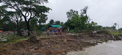
Ghoramara Island’s 50-year erosion crisis
Roma K M, Wikimedia Commons, CC-BY-SA-4.0

In India, climate disasters are often imagined as sudden and destructive events. Cyclones tear through coastal villages. Floods submerge cities within hours. Heatwaves strain hospitals and power grids. These crises command headlines and emergency responses.
Ghoramara Island in the lower Hugli Estuary presents a different reality. Here, climate change does not arrive in a single violent episode. It removes land gradually, metre by metre, year after year. What was once a settled island supporting thousands has steadily contracted, leaving behind shrinking habitations and uncertain futures. The loss is slow enough to escape national attention, yet relentless enough to redraw maps and displace lives.
Along the West Bengal coastline, particularly in the Sundarbans, including Ghoramara and Sagar Islands, shoreline change has intensified. Severe erosion driven by cyclones, sea level rise, and natural delta processes has caused significant land loss and saltwater intrusion. Some stretches show land accretion, reflecting the complex interaction of natural forces and human interventions, but the overall trend for vulnerable islands remains deeply concerning.
A 2023 scientific paper by Mondal and colleagues documents this transformation with clarity. Using five decades of satellite data and geospatial modelling, the researchers trace how Ghoramara has shrunk, shifted, and fragmented. Projections indicate further contraction by 2032. The findings go beyond documenting coastal erosion. They raise a larger question about how India governs slow-onset climate disasters that displace people gradually, without the spectacle of sudden destruction, and therefore without sustained political urgency.
From a living island to a residual fragment
In 1972, Ghoramara covered roughly 7.2 square kilometres. By 2022, that figure had fallen to 3.6 square kilometres. In other words, half the island has vanished within fifty years. The authors estimate that if current trends continue, Ghoramara may be reduced to about 2.6 square kilometres by 2032—a landmass barely capable of sustaining permanent settlement. Another 2025 study by Tuli Sen estimates that the total area was reduced from 8.145 sq km in 1990 to 3.59 sq km in 2024.
This is not conjecture. The study relies on multi-temporal Landsat satellite data and the US Geological Survey’s Digital Shoreline Analysis System (DSAS), a globally accepted tool for calculating shoreline movement. Two metrics anchor the analysis:
End Point Rate (EPR), which measures the annual rate of shoreline retreat or advance.
Shoreline Change Envelope (SCE), which captures the total extent of shoreline movement over time.
Ghoramara’s mean End Point Rate (EPR) is –10.59 metres per year, with extreme sections eroding at nearly –36 metres per year. In the island’s northern reaches, the shoreline has shifted inland by 676 to 855 metres since the early 1970s. These are not marginal changes; they represent the loss of entire agricultural fields, homesteads, and community spaces.
Why the North is disappearing faster
One of the most important contributions of the paper is its spatial specificity. Erosion on Ghoramara is not uniform. The north, north-west, and north-east coasts are eroding far more rapidly than the southern margins. This pattern is tied to estuarine dynamics rather than open-ocean wave attack alone.
The Hugli estuary is a highly engineered river system. Upstream barrages, navigation dredging, embankments, and altered flow regimes have changed how sediment moves through the delta. Sediment—the raw material of land-building in deltas—is no longer reaching downstream islands in sufficient quantities. As a result, Ghoramara is experiencing what scientists call sediment starvation.
At the same time, relative sea level rise, recorded at the nearby Haldia tide gauge, is increasing tidal penetration and bank instability. The study’s analysis of Revised Local Reference (RLR) sea-level data shows a clear long-term upward trend, intensifying erosion during high tides and storm surges.
This interaction—less sediment coming in, more water energy acting on fragile banks—is lethal for small deltaic islands.
The limits of embankments and the illusion of control
For decades, the primary response to erosion in the Sundarbans has been embankment construction and repair. Ghoramara is ringed by embankments, many of which have failed repeatedly. The study implicitly underscores why this approach is inadequate.
Hard embankments reflect wave energy rather than absorbing it, often accelerating scouring at their base. When they fail, they do so catastrophically, allowing saline water to flood agricultural land and freshwater ponds. Rebuilding embankments on a shrinking landmass also creates a vicious cycle: more money is spent defending less land, while the underlying drivers of erosion remain unaddressed.
The paper’s recommendation to expand mangrove vegetation is therefore not cosmetic. Mangroves act as living infrastructure, stabilising sediments, reducing wave energy, and promoting accretion under suitable conditions. Yet mangrove restoration in inhabited islands like Ghoramara has been piecemeal, often treated as an environmental project rather than a core adaptation strategy.
When erosion becomes displacement
Perhaps the most unsettling aspect of Ghoramara’s story lies beyond geomorphology. As land disappears, people are forced to move—but without any formal recognition as displaced persons.
The study notes that around 3,000 people were displaced in 2016, following accelerated erosion linked to the earlier submergence of Lohachara Island, a neighbouring island that disappeared entirely in the early 2000s. Families relocated from Lohachara to Ghoramara found themselves displaced again within a decade.
India’s disaster management framework is poorly equipped to handle such slow-onset displacement. There is no clear policy category for people who lose land gradually due to erosion. They are not cyclone victims. They are not beneficiaries of large dam resettlement packages. As a result, relocation is ad hoc—often to marginal lands on the mainland, without secure tenure, livelihood support, or social integration.
Why projections matter: The politics of 2032
One of the most policy-relevant aspects of the paper is its projection of shoreline change to 2032. Using the End Point Rate model, the authors estimate continued retreat along most of Ghoramara’s coastline, particularly along the western and southern margins.
This ten-year horizon matters. It means that displacement is not an abstract future risk; it is a governable timeframe. Authorities know, within reasonable bounds, how much land is likely to remain and where erosion will intensify. Yet there is little evidence that such projections are being integrated into district or state planning.
Without proactive intervention, the likely outcome is familiar: sudden embankment failure, emergency evacuations, temporary shelters, and long-term social marginalisation.
Ghoramara as a canary for India’s deltas
Ghoramara is often described as a “dying island", but that framing misses the larger point. What is dying is not just an island, but a mode of governance that treats deltas as static landscapes.
Across India’s coastline—from the Mahanadi delta in Odisha to parts of the Cauvery delta in Tamil Nadu—similar processes are unfolding. Shorelines are shifting, sediment regimes are changing, and climate signals are amplifying long-standing vulnerabilities. What Ghoramara offers is unusually clear empirical evidence of these processes over time.
In that sense, the island is a sentinel site. It shows what happens when coastal change is monitored scientifically but governed politically as an afterthought.
What a serious response would look like
The study’s findings point to a set of recommendations that go far beyond technical fixes.
Institutionalise shoreline monitoring: Remote sensing and DSAS-based analysis should be embedded within state coastal zone management authorities, not confined to academic studies. Annual or biennial shoreline audits would allow early identification of zones where habitation is no longer viable.
Shift from defence to adaptation: Not all land can or should be saved. Planned, dignified retreat—supported by housing, livelihoods, and legal tenure—must replace emergency displacement.
Treat sediment as infrastructure: River basin management must explicitly account for downstream sediment needs. Navigation, flood control, and delta stability cannot be planned in isolation.
Recognise climate-induced displacement legally: People displaced by erosion should have clear entitlements under housing, employment, and social protection schemes. Without legal recognition, displacement becomes permanent precarity.
Invest in ecosystem-based buffers: Mangroves, vegetated banks, and hybrid "green-grey" solutions offer longer-term resilience than embankments alone, particularly in tidal deltas.
The cost of ignoring slow disasters
Ghoramara’s erosion has been visible from space for decades. Its decline has been measured, mapped, and modelled. What has been missing is political urgency.
The lesson of this island is not that climate change is unpredictable. It is that slow disasters are easier to ignore than sudden ones, even when the evidence is overwhelming. If India continues to treat places like Ghoramara as peripheral, it will face not just disappearing islands but a growing population of unrecognised climate migrants—people whose lives unravel quietly as the land beneath them vanishes.
By the time Ghoramara finally slips below the waterline, it will be too late to ask what could have been done. The science has already answered that question. The real test now is whether governance is willing to listen.