- Topics
- Feature
- Opportunities & Events
- About
- Hindi Portal
- Data
- Topics
- Feature
- Opportunities & Events
- About
- Hindi Portal
- Data
In October 2020, water levels in some neighbourhoods of Hyderabad reached 12 feet. At Nadeem Colony in Tolichowki, one of the first settlements to report rising waters, boats were deployed to rescue people and move them to safer grounds.
Photo courtesy: Harsha Vadlamani

On the morning of October 14, 2020, many residents of Hyderabad woke not to rain but to water already inside their homes. Doors had given way under the pressure of floodwaters. Streets had disappeared beneath muddy currents. Families carrying children, documents and a few salvaged belongings climbed onto terraces and rooftops. Mobile networks faltered. In several neighbourhoods, rescue teams had not yet arrived. What arrived first were the neighbours.
The flood followed one of the most intense rainfall events in Hyderabad's recorded history. Triggered by a cyclonic depression over the Bay of Bengal known as Deep Depression BOB 02, the city received its highest October rainfall since 1903. More than fifty people lost their lives. Hundreds of homes were damaged or washed away. Roads, basements and entire neighbourhoods remained submerged for days.
Urban floods have become a familiar feature of India's cities. Chennai's devastating floods in 2015, the recurring monsoon paralysis of Gurugram and Mumbai's annual struggle with inundation have all revealed how rapid urban expansion, changing rainfall patterns and stressed drainage systems are creating new vulnerabilities.
Yet floods are often remembered through rainfall statistics, engineering reports and images of submerged streets. What if we remembered them through the people who stepped into the water when the city could not?
The floods of 2020 exposed not only weaknesses in Hyderabad's urban infrastructure but also the hidden networks that helped the city survive. As water moved through lakes, nalas, roads and neighbourhoods, it revealed a deeper story about the relationship between people and water. It also revealed a simple truth: long before rescue boats, emergency forces and official relief systems become visible, communities themselves often form the first infrastructure of response.
Colonies in Hyderabad were submerged overnight with floodwater mixed with sewage.
Photo courtesy: Harsha Vadlamani
Urban floods are often analysed through an engineering lens, measured in terms of rainfall intensity, drainage capacity and hydraulic modelling. But the 2020 floods in Hyderabad revealed a more complex story about how water moves through an interconnected urban landscape.
In December 2022, UNICEF commissioned a study with Hyderabad Urban Lab to examine how the disaster unfolded across neighbourhoods and how institutions and informal networks responded. The study surveyed 279 households across twelve locations in the city, covering 1,524 individuals.
Drawing on the field investigation, Ebin Paul, a disaster risk reduction practitioner and spatial analyst involved in the study, identified three broad patterns of flooding. In some neighbourhoods, flooding resulted from the overflow of nalas and river channels, affecting settlements along major drainage corridors, including Al Jubail Colony, Rasoolpura, and areas along the Musi River near Chaderghat and Musarambagh.
Elsewhere, flooding resulted from breaches of tank bunds, as reported in Baba Nagar, Hashimabad and Bandlaguda. A third pattern emerged in settlements located within tank catchments, where rising water levels across interconnected lakes and drainage channels spilled into surrounding neighbourhoods, affecting areas such as Tolichowki, Balapur, Osman Nagar, parts of the Bowenpally Lake catchment and Saroornagar.
These were not separate flood events. They were connected through Hyderabad's wider tank and drainage network. Water first began accumulating around Balapur and Osman Nagar as upstream tanks filled and runoff moved through a chain of nalas and smaller water bodies. Residents trying to understand the source of the flooding traced its path through adjoining settlements such as Jalpally and water bodies like Palle Cheruvu.
Attempts to divert water in one location often shifted risk elsewhere. When water was prevented from entering Osman Nagar, pressure built further downstream, contributing to flooding in Al Jubail Colony. Later, the breaching of a tank bund near Gurram Cheruvu released another surge of water from the Balapur side, sending floodwaters towards Baba Nagar, where some of the most severe damage occurred.
The water entering homes and streets was rarely clean rainwater. It was a mixture of storm runoff and sewage moving through an overstretched drainage system. The flood also unfolded at different speeds. In Baba Nagar, a lake bund breach during the night sent water rushing into the settlement within hours, killing more than twenty residents before dawn. By the following day, much of the water had receded.
In contrast, Al Jubail Colony experienced a slower but more prolonged flood. As lakes filled and nalas overflowed, homes remained inundated for ten to fifteen days, forcing residents either to evacuate or remain stranded on upper floors.
Despite the unprecedented rainfall brought by the cyclonic depression, the flood did not unfold as a single event. It moved through Hyderabad as a chain reaction across interconnected lakes, nalas and catchments. In some places, the city could not hold the water. In others, it could not release it.
Map of locations affected by flooding across the three typologies: river/nala overflow, tank catchment and bund breakage.
Map Courtesy: Hyderabad Urban Lab
For Umar, a volunteer with Safa Baitul Maal, a Hyderabad-based welfare trust involved in education, livelihood support and assistance to low-income families, the night of October 2020 began like any other. By dawn, Balapur, a locality within the catchment of Balapur Lake, was under water.
“We slept around eleven or twelve,” he recalled. “By five or six in the morning, the water level was already so high that the pressure had broken the doors of houses and shops.” Residents climbed onto terraces while others remained trapped inside their homes. Volunteers themselves had little idea what they were facing. “We didn’t even have a boat,” Umar said. “First, we got into the water and tried to understand what people needed.”
Improvisation became the first line of response. Wood and metal drums were tied together to create makeshift flotation devices, while ropes were stretched across flooded lanes to help people move through strong currents. Children were evacuated first. Elderly residents were lifted onto wooden chairs, sometimes secured with tied sarees, and carried through the water by fellow volunteers.
The work was slow, exhausting and dangerous. Urban floodwater is rarely just rainwater. It carries sewage, waste and contaminants from overflowing drains and blocked sewer lines. In nearby Osman Nagar, volunteers spent hours standing in polluted water.
“Dadode ho gaye,” Umar said, describing the painful sores that appeared on their legs after prolonged exposure to the contaminated floodwaters. Long before formal rescue teams could reach every affected area, residents became first responders. Their knowledge of neighbourhoods, vulnerable households and navigable routes often proved as valuable as equipment.
Several localities, such as the Al Jubail colony, continued to be under several feet of water even after the rains stopped.
Courtesy: Harsha Vadlamani
As floodwaters spread across Hyderabad, communication became as important as rescue. Khalida Apa, who worked with volunteers across several affected areas, recalled that many households lost contact with relatives as phone networks failed. Families often had limited information about rising water levels or evacuation options.
For many women, leaving home with unfamiliar rescue teams was not a straightforward decision. In several locations, rescue efforts were largely carried out by male volunteers. The situation highlighted a broader challenge within disaster management systems where women remain underrepresented in emergency response. Despite commitments under the Sendai Framework for Disaster Risk Reduction, women constitute only about 20 percent of trained volunteers in India's Aapda Mitra programme.
Where formal preparedness systems revealed gaps, community networks stepped forward. Early on the morning of October 14, Mohammed Azam Khan, director and co-founder of the Social Data Initiatives Forum (SDIF), began receiving distress calls from across Hyderabad. More than one hundred colonies had flooded overnight. By eight o'clock that morning, Khan and his son Ibrahim had reached Nadeem Colony in southern Hyderabad with five boats and two volunteers from the Yacht Club of Hyderabad.
In those crucial first hours, much of the city's response was coordinated through civil society organisations, local volunteers and informal community networks rather than a fully integrated emergency system. For many residents, help arrived not through institutions but through people they already knew.
The floodwaters eventually receded, but recovery proved far more difficult than rescue. Across southern Hyderabad, from Chaderghat and Malakpet to Attapur, function halls were transformed into relief centres where volunteers distributed food, clothing and essential supplies. Yet those working on the ground quickly realised that emergency assistance addressed only the first stage of the crisis.
Some of the relief items were distributed to the rescued people immediately.
Volunteers from Safa Bait ul Maal who surveyed affected households found that floodwaters had risen as high as eight feet in several homes. Walls had collapsed. Furniture and utensils had been washed away. Food stocks were destroyed, while household appliances lay submerged beneath mud and sewage. Many houses remained uninhabitable long after the water receded.
Relief workers observed that recovery is often measured through the replacement of losses. Yet households do not necessarily return to normal life because they receive new possessions. Recovery occurs when people regain the ability to carry out everyday routines.
Muqeetuddin of Safa Bait ul Maal drew attention to an often overlooked aspect of recovery: “During the time of the flood, most household items such as refrigerators, washing machines, water motors and air coolers were damaged when water entered them. If a skilled technician repairs these appliances, they can start working properly again. People regain their essential household assets, technicians earn a livelihood, and not everything is lost. Our relief counters should also think in this direction. It is a cost-effective way to bring normalcy when it is most needed.”
Building back agents: Young volunteers of Safa Bait ul Maal assemble essentials from functional markets and covert shadikhanas, transforming them into flood-relief centres.
His observation highlights an important lesson for disaster resilience. Recovery is not only about rebuilding infrastructure or distributing relief. It is also about restoring the practical systems that make everyday life possible.
The floods also generated another form of knowledge that rarely appears in official disaster plans. Residents began rethinking how they would prepare for future monsoons. Shopkeepers considered keeping smaller stocks during heavy rainfall periods or storing goods above ground. Families discussed maintaining digital copies of important documents, placing valuables on higher shelves and reorganising domestic spaces to reduce future losses.
These adjustments may appear modest, but together they form an important layer of preparedness. They represent local knowledge generated through lived experience with water and become part of the practical infrastructure through which households absorb and recover from future shocks.
The years following the 2020 floods saw significant investments in flood mitigation across Hyderabad. New box drains were constructed, existing nalas were widened, and drainage infrastructure became a central focus of urban flood management. Yet those working at the intersection of water, policy and communities caution that technical interventions alone cannot resolve the problem.
S. Q. Masood, a Hyderabad-based social activist who has long documented the city's water bodies and worked on issues of law, policy and development, argues that engineering solutions can sometimes shift risk rather than eliminate it. “Earlier, Macca Colony used to flood,” he noted, “but now it is Bilal Nagar.” His observation points to a recurring challenge in urban flood management. Water redirected away from one location often accumulates elsewhere.
According to Masood, the problem lies not only in where drains are built but also in how they function within the wider drainage system. Maintaining the correct gradient in box drains is difficult, and once constructed, design flaws are often difficult to correct. In several locations, this has resulted in backflow and stagnant water.
Roadside pipes intended to carry rainwater frequently become clogged with silt and garbage. Covered drains often become difficult to maintain, while wastewater from adjoining properties enters stormwater systems, mixing sewage with runoff before eventually flowing into lakes and nalas. In many places, infrastructure intended to reduce flooding may be creating new patterns of water accumulation.
This does not mean engineering is unnecessary. New technological tools are emerging from the city itself, including a project at Osmania University that uses flow sensors in stormwater drains to monitor water levels and anticipate flood surges.
But the floods revealed a larger reality. Water moves through interconnected tanks, catchments, drainage channels and neighbourhoods. Without understanding these wider hydrological systems, technical solutions risk solving one problem while creating another elsewhere in the city.
The lesson from Hyderabad is that resilience cannot be built through infrastructure alone. It depends equally on local knowledge, neighbourhood networks and an understanding of how water moves through both the city and the lives of the people who inhabit it.
Essentials from functional markets like vessels, buckets, pillows, blankets and groceries are arranged in the temporary flood relief shelters for distribution.
For Anant Maringanti, geographer and founder-director of Hyderabad Urban Lab, understanding floods requires understanding the city itself. “Hyderabad is not simply a collection of lakes, drains and neighbourhoods but a landscape organised through interconnected catchments," he says.
Parts of the western city, including Kukatpally, Ramachandrapuram and Gachibowli, drain towards the Godavari basin, while eastern areas fall within the Krishna basin. Situated on the Deccan plateau, Hyderabad is shaped by a dispersed drainage system in which water moves across multiple slopes and pathways.
Historically, tanks formed the backbone of this hydrological landscape. Thousands of interconnected water bodies slowed, stored and redistributed runoff across the plateau. Among the most prominent was the sixteenth-century Hussain Sagar, part of a wider system that functioned not only as water storage infrastructure but also as a mechanism for moderating floods. By the early twentieth century, these linked tanks formed an extensive network through which water moved across the city.
Over the past four decades, however, rapid urbanisation has transformed this landscape. Roads, layouts and real estate developments have hardened tank edges and interrupted channels through which water once circulated. Yet Maringanti cautions against reducing this transformation solely to the language of encroachment.
Settlements around tanks are also tied to broader questions of housing, land access and urban growth. People often occupy vulnerable locations because cities expand without creating sufficient space for those who live and work within them. The challenge, therefore, extends beyond protecting water bodies. It requires recovering a systemic understanding of Hyderabad as a catchment landscape while confronting questions of housing, development and environmental justice.
The floods also revealed significant gaps in how cities understand water movement. While rainfall data is increasingly available, systematic information on where flooding occurs and how water behaves once it accumulates remains limited. Following intense rainfall events in August and September 2025, spatial analysts such as Teja Malladi began compiling rainfall records and reported flood locations into mapped visualisations across Hyderabad.
Initiatives such as Hyderabad Flood Watch have built on these efforts by crowdsourcing observations from residents. Volunteers document water depth, note whether water is stagnant or flowing, record debris and garbage, and mark precise GPS locations. Such initiatives recognise a basic reality of urban hydrology: floods cannot be fully understood through models alone.
Water interacts differently with roads, buildings, drains, slopes and neighbourhood landscapes, often in ways visible only through direct observation. Over time, these citizen-generated records become another form of infrastructure, where knowledge is produced collectively through lived experience.
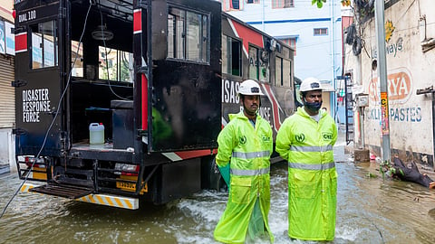
Recognising the value of community knowledge does not diminish the role of the state. Flood management in a rapidly expanding metropolis requires institutional capacity, equipment and long-term planning. As Mahendra Rajaram of UNICEF notes, “Telangana established its State Disaster Response Force in 2024, with its first squad becoming operational later that year. Modelled on the National Disaster Response Force, it is being equipped with specialised vehicles, boats and disaster-management tools.”
Yet practitioners repeatedly emphasise that equipment alone cannot guarantee an effective response. Abdul Muhaimin Azhar, civic and social sector professional and vice-president of Safa-Bait-ul-Maal, argues that “neighbourhood groups often remain the most effective first responders because they know local streets, vulnerable households and residents who may need immediate assistance."
Early warning, in this sense, is not only about forecasting rainfall but also about ensuring that communities know how to protect vulnerable residents, secure belongings, and activate local support when warnings arrive. Such capacities are rarely created during crises; they emerge through relationships built long before disaster strikes.
Programmes such as Aapda Mitra and initiatives like the Inter-Agency Group in Telangana increasingly seek to strengthen coordination between government agencies, community organisations and civil society networks. The challenge is not to choose between state capacity and civic action but to build systems in which both reinforce one another.
A base map of water bodies and stream paths by Hyderabad Urban Lab
More than a century ago, Hyderabad reorganised itself after the Musi floods of 1908 through reservoirs, embankments and new planning institutions. The floods of 2020 offer a different lesson. Water continues to move through catchments that predate roads, neighbourhoods and administrative boundaries. As rainfall becomes more intense and urban landscapes grow more complex, cities must learn not only how to control water but also how to live with it. That challenge is technical, political and ecological. But it is also profoundly human.
The volunteers are carrying elderly residents through floodwaters. The neighbours were sharing information when communication systems failed. The community organisations were coordinating boats before formal rescue teams arrived. The residents are documenting flood levels and tracing water through their neighbourhoods. These people formed the city's first line of response.
The floods revealed that the first infrastructure of resilience is rarely concrete, steel or machinery. It is the network of relationships, local knowledge and collective action that exists long before a crisis begins. Strengthening these capacities may prove just as important as rebuilding drains, widening nalas or constructing new flood-control systems.
The city has heard this wisdom before. As Muhammad Quli Qutb Shah wrote:
Mera shehar logan se mamoor kar
Rakhya joon toon darya mein min ya sami
Oh God, fill my city with people,
as you have filled the river with fish.
Four centuries later, those words invite a different reading. We often ask how a city can defend itself against water. Hyderabad's floods suggest a more difficult question: how can a city remember that it is part of a watershed rather than separate from it?
Water will return. It will follow old catchments, forgotten channels and pathways that long predate roads, layouts and administrative boundaries. The future of urban resilience may depend less on whether cities can overpower these flows than on whether they can understand them and organise themselves around them.
In that sense, the first infrastructure is not a drain, a wall or a reservoir. It is the collective capacity of people to recognise their interdependence with one another and with the landscapes they inhabit. When the next flood arrives, that may be the infrastructure that matters most.
This story is produced as part of the India Water Portal Regional Story Fellowship 2025.