- Topics
- Feature
- Opportunities & Events
- About
- Hindi Portal
- Data
- Topics
- Feature
- Opportunities & Events
- About
- Hindi Portal
- Data
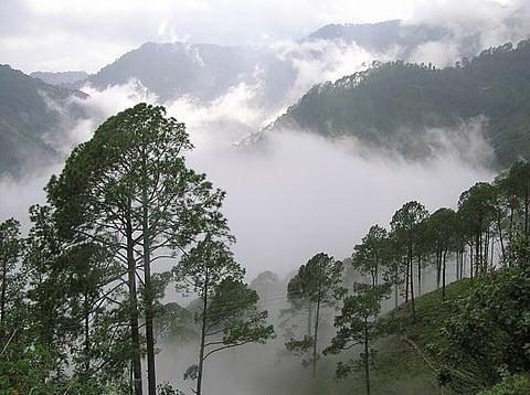
Fog covered hills in Nainital. Researchers have identified several high altitude zones in Pithoragarh where fog harvesting could strengthen drinking water security for mountain communities.
Udayan, Wikimedia Commons

Water has shaped life in the Central Himalayas for centuries. Across Uttarakhand, traditional springs known as dharas and naulas have sustained households, farms, and communities through generations. Today, however, these lifelines are under growing stress.
Satellite observations and long term climate records reveal a troubling trend. Groundwater reserves are declining, rainfall patterns are changing, and many mountain villages are facing increasing seasonal water shortages. As conventional sources become less reliable, researchers are exploring an unconventional question: can water be harvested directly from the atmosphere?
A recent seminal study titled "Machine learning-based mapping of fog water harvesting potential in Pithoragarh, Uttarakhand: Evaluating climate scenarios and geospatial influences", published in Physics and Chemistry of the Earth, suggests that the answer may be yes. It is authored by Chiranjit Singha, Kishore Chandra Swain, Biswajeet Pradhan, Armin Moghimi, Babak Ranjgar, Shahid Gulzar, and Hetvi Shah.
Using machine learning, remote sensing, and climate modelling, the study identifies locations where dense mountain fog can be captured and converted into a reliable source of freshwater. The findings offer a practical and low-cost approach to strengthening water security in water-stressed Himalayan regions.
The Central Himalayas are undergoing a significant hydrological transformation. Data from Gravity Recovery and Climate Experiment (GRACE) satellite products between 2002 and 2023 show that the region's Equivalent Water Thickness declined from a baseline of 42.099 cm to minus 121.367 cm. This corresponds to an annual localised water loss of between minus 5.65 cm and minus 6.79 cm.
At the same time, meteorological records spanning 1960 to 2023 indicate a statistically significant decline in both monsoon and winter precipitation. As surface and groundwater sources diminish, mountain communities are experiencing growing seasonal water stress. These changes are affecting agriculture, livelihoods, and demographic patterns across the region.
Against this backdrop, researchers are exploring atmospheric water as an alternative source that could complement existing water systems while supporting Sustainable Development Goal 6 on clean water and sanitation.
Fog harvesting depends on one critical factor: knowing where fog occurs consistently and in sufficient density. This is particularly challenging in a mountainous district like Pithoragarh, which covers 489.26 square kilometres and ranges in elevation from 416 metres to 2,474 metres. Weather conditions can vary dramatically from one ridge to another, making broad weather forecasts inadequate for identifying suitable fog harvesting locations.
To address this challenge, researchers combined field observations from 200 georeferenced sampling locations with 23 environmental variables related to topography, climate, terrain characteristics, and hydrology. These sampling sites included high fog zones such as Bastey, Sirrha, Halipati, and Kurma. The goal was to understand the complex interactions that influence fog formation and identify locations where atmospheric moisture can be captured effectively.
Reading the landscape: How computers predict the fog
Predicting where fog will thickest across a rugged region like Pithoragarh is incredibly challenging. The district climbs from low valleys to high peaks, meaning weather conditions change from one ridge to the next. Fog is a fickle thing, shaped by a complex mix of wind, temperature, and terrain shape. To understand these patterns, researchers spent months on the ground, mapping 200 real-world fog hotspots in mountain villages like Bastey and Sirrha. They fed these real-world observations, along with 23 environmental factors, into five different machine learning computer models to let the computers learn exactly what triggers mountain fog.
The results revealed that a few key factors matter above all else. Elevation is the most important factor by far, followed closely by how exposed a ridge is to the wind and the overall speed of that wind. As warm, moist air travels up the steep mountain slopes, it naturally cools down and condenses into thick fog, making high ridges ideal target zones. Interestingly, the computers also proved that human footprints alter these patterns. The models showed a clear drop-off in fog near busy roads and clustered buildings. Human structures retain heat and disrupt natural airflow, creating warm micro-climates that cause fog to evaporate rather than settle.
Finding the sweet spots: Where the models agree
The study’s computer models didn't just guess; they were rigorously tested against real-world data to see which ones performed best. Two advanced algorithms—Adaptive Boosting and Gradient Boosting Machine proved to be incredibly accurate, correctly identifying top-tier fog locations nearly 99% of the time. Simpler models struggled because they treated environmental factors as completely separate pieces of data, failing to realise that in the mountains, elevation, temperature, and wind are all deeply connected.
When these top-performing models were translated into regional maps, they revealed that over 43% of Pithoragarh has a "Very High" potential for harvesting fog. These high-yield zones are clustered tightly across the northern and central mountain corridors. The maps highlight that slopes with a moderate angle—specifically those tilted between 26 and 52 degrees—act as perfect natural roadblocks, stopping fog-laden winds and forcing them to pass through a single channel. It is in these precise geographic bottlenecks where water-catching infrastructure will be most effective.
Planning for tomorrow: Fog harvesting in a changing climate
Mountain weather is changing, which means water projects designed today must be resilient enough to work decades from now. To see how future climate shifts might affect fog patterns, the research team connected their models to major international climate projections, looking ahead at various environmental scenarios up to the year 2055. They tested both a moderate climate future and a high-emissions, fossil-fuel-heavy future.
The future models yielded surprising and encouraging news for local water security. Even as the climate warms, atmospheric moisture will remain a highly viable resource. Under both climate scenarios, the models predict that the areas ideal for fog harvesting will actually expand, potentially covering around 49% to 51% of the district. This happens because warmer air holds more moisture, leading to dense, heavy fog when temperatures drop sharply overnight in the high hills. By identifying a core area of about 22% of the district that remains perfectly stable across every single future model, the study gives planners a foolproof map of where investments will be safest over the next thirty years.
To translate these machine learning models into a reliable water source for Uttarakhand's mountain communities, regional planners must move from theoretical mapping to structured execution. The following four technical and policy interventions outline a practical path forward:
1. Spatial zoning and core site selection
Infrastructure development must target the steady 21.5% to 22.8% north-central mountain corridor identified as highly resilient across all future climate models. Harvesting systems should be positioned on slopes between 26.27° and 52.51° that face prevailing wind directions, maximising the capture of passing fog droplets. To protect these micro-climates, planners should establish strict 500-metre buffer zones around harvesting sites, restricting major road construction and heavy building development to prevent urban heat islands from dispersing fog fields.
2. Standardizing high-yield harvesting technology
Rather than relying on basic monofilament meshes, installations should use advanced Raschel-weave polyethylene mesh nets treated with specialised hydrophilic coatings. These dual-performance meshes optimise both the initial interception of tiny fog droplets and the rapid shedding of gathered water down into collection troughs, preventing the net from clogging and maximising daily yields. This structural mesh must be mounted on durable, corrosion-resistant galvanised steel frames designed to withstand the strong wind power densities (350.64 W/m}^2) common across high-altitude ridges.
3. Integrating gravity-fed storage systems
To eliminate operational costs, fog collectors should be linked to gravity-fed distribution networks that pipe water down from high ridges directly to lower-altitude villages. Given that winter valley fog peaks between 6:00 AM and 8:00 AM, collection systems must feature closed, insulated storage tanks to prevent evaporation during warmer daytime hours. This raw water supply should feed directly into local multi-tier filtration units equipped with in-line chlorination systems, ensuring it meets safe drinking water standards for immediate domestic use.
4. Co-designing infrastructure with indigenous communities
To ensure long-term viability, projects should be co-designed alongside traditional mountain communities, including the Bhotiya and Van Gujjar tribes, matching infrastructure development with seasonal migration and grazing patterns. Local water governance groups—such as Pani Samitis—should be trained to handle routine maintenance, mesh cleaning, and system repairs, moving away from top-down management models.
Finally, the state government should incorporate atmospheric water harvesting into its State Action Plan on Climate Change (SAPCC), allocating dedicated funding and subsidies to scale these systems across water-stressed Himalayan districts.
The water crisis unfolding across the Central Himalayas is often framed as a story of disappearing springs and declining rainfall. While these challenges are real, this research points to a new possibility: the atmosphere itself may become an important source of freshwater.
By combining machine learning, satellite observations, and local environmental knowledge, the study identifies where fog can be transformed from a seasonal weather phenomenon into a practical water resource. More importantly, it demonstrates that climate adaptation need not always rely on large engineering projects. In some cases, solutions can emerge from understanding natural processes more precisely and working with them.
For Uttarakhand's mountain communities, the question is no longer whether fog exists in abundance. The question is whether that invisible resource can be captured effectively enough to help secure the future of water.