- Topics
- Feature
- Opportunities & Events
- About
- Hindi Portal
- Data
- Topics
- Feature
- Opportunities & Events
- About
- Hindi Portal
- Data

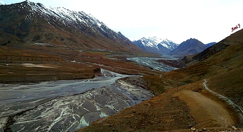
Himachal Pradesh’s Spiti Valley has been identified as India’s first Cold Desert Biosphere Reserve under UNESCO’s Man and the Biosphere (MAB) Programme at the 37th session of UNESCO’s International Coordinating Council of the MAB Programme. India now has 13 sites in UNESCO’s World Network of Biosphere Reserves.
The Cold Desert Biosphere Reserve is spread across 7,770 sq. km in Lahaul-Spiti district and includes the Spiti Wildlife Division (7,591 sq. km) and parts of the Lahaul Forest Division, covering Baralacha Pass, Bharatpur and Sarchu. The reserve includes a 2,665 sq. km core zone, 3,977 sq. km buffer zone and 1,128 sq. km transition zone with important protected areas such as the Pin Valley National Park, Kibber Wildlife Sanctuary, Chandratal Wetland and the Sarchu Plains.
Although the cold desert ecosystem is shaped by extreme climate, rugged terrain and fragile soils, its landscape supports remarkable biodiversity and includes 655 herbs, 41 shrubs and 17 tree species, including 14 endemic and 47 medicinal plants and 17 mammal and 119 bird species. The snow leopard is the flagship species in the region while the Tibetan wolf, red fox, Himalayan ibex, golden eagle, Himalayan snowcock and bearded vulture are other animals found in the region (Mongabay, India).
MGNREGA funds will now be prioritised for water conservation activities across the country, to help boost groundwater levels and accelerate conservation of water resources. In a notification issued on September 23, The Union Ministry of Rural Development has amended paragraph 4(2) of Schedule I of the MGNREGA Act, which previously allowed the Gram Panchayat to prioritise works based on local resources, potential of the area, and needs.
According to the notification, it is now mandatory to spend 65 percent of MGNREGA funds on water conservation projects in “dark zones” implying areas with excessive groundwater exploitation. This amount will be 40 percent for “semi critical” districts and 30 percent for other districts.
This policy shift will ensure that resources get directed to areas where they needed the most, shifting from reactive measures to preventative, long-term water management (Down To Earth).
The monsoon withdrawal process from western Rajasthan has started on September 14, three days before the customary date of September 17, following an early start on May 24 rather than June 1. There have been striking disparities in rainfall patterns this year. While the country as a whole has witnessed 7 percent above normal rainfall as of September 15th, regional differences have been substantial.
The historically rainy east and northeast have witnessed inadequate rainfall with Meghalaya showing the largest deficit at 44 percent, followed by Arunachal Pradesh at 40 percent. The normally dry Rajasthan had 68 percent above normal rainfall. The Union Territory of Ladakh has witnessed a whopping 413 percent excess rainfall this year!.
Eighteen states and union territories have received normal rainfall, while 12 states and UTs—six of which were in northwest India—recorded excess rain. Twenty percent of the districts had inadequate rainfall, 33 percent had excessive or significantly excessive rain, and 47 percent reported normal rainfall. These changing rainfall patterns occurred with simultaneous occurrences of floods and drought like conditions in various areas (SIGMA EARTH).
Streamflow drought occurs when less water than usual moves through rivers. Synchronous drought, in which multiple river basins experience drought simultaneously, can be extremely severe and far-reaching and can seriously disrupt the welfare of nearby communities, agriculture, and economies.
Synchronous droughts are increasing with the weakening of the summer monsoon and the warming of the Indian ocean as anthropogenic emissions and excessive groundwater pumping continue in the Indian subcontinent , where major rivers support more than 2 billion people.
A recent study reconstructed streamflow records over more than 800 years by combining several decades of streamflow measurements from 45 gauge stations along India's major rivers along with temperature and precipitation data.
The researchers also referred to the Monsoon Asia Drought Atlas, along with historical records of changes in climate patterns like El Niño, the Pacific Decadal Oscillation, and the Indian Ocean Dipole to explore their connections with the frequency of droughts.
The study found that there was an increase in the frequency of synchronous drought between 1850 and 2014 compared with preindustrial centuries and the likely cause was connected to warming climate (PHYS.ORG).
A recent study done by Panjab University's Geo-Environmental Research Laboratory in collaboration with Baba Farid NGO, Faridkot, analysed blood and hair samples of children in the age group 5-15 years and groundwater samples across Bathinda and Rupnagar in Punjab and Chandigarh.
The study found high levels of lead and uranium in the blood samples of of children and groundwater. As high as 26.17 percent samples exceeded the WHO's safe limit of 3.5 micrograms per decilitre for lead in the water. In Bathinda, 32.62 percent samples exceeded the WHO's limit for uranium followed by Rupnagar at 19.35 percent and Chandigarh at 26.32 percent.
Thirty nine percent of hair samples were above the safe limit for lead. Seventy nine percent samples in Chandigarh, 39 percent samples in Rupnagar and 26 percent samples in Bathinda exceeded the safe limit. All groundwater samples in Bathinda exceeded the WHO and Bureau of Indian Standards limits for uranium as compared to Rupnagar and Chandigarh (The Economic Times).
This is a roundup of news updates from September 16, 2025 to September 30, 2025. Read our news updates here.