- Topics
- Feature
- Opportunities & Events
- About
- Hindi Portal
- Data
- Topics
- Feature
- Opportunities & Events
- About
- Hindi Portal
- Data
India's crowded coasts.
IWP Flickr photos.

The world has always gravitated towards the sea. Ports built trade, rivers carried fertile soil to the coast, and cities rose where land met water. Today nearly half of the world’s urban population lives within 100 kilometres of a coastline, and these regions generate more than half of global economic output.
But the same coastlines that support prosperity are also becoming increasingly fragile. Rising seas, shifting rainfall, polluted waters, and growing demand for freshwater are reshaping the risks faced by coastal communities.
A new global study that maps water-related threats along coastlines offers a stark insight into how these pressures are distributed. The findings place Asia at the centre of global vulnerability. Within this landscape, India stands out as one of the countries where dense populations and overlapping water stressors converge, placing millions of people at risk.
Coastal zones have always attracted human settlement. Access to trade routes, fisheries, fertile delta lands, and economic opportunities has led cities and industries to cluster near the sea. Today, these regions form some of the most densely populated parts of the planet.
However, the same regions are increasingly exposed to environmental stress. Climate change is intensifying storms, raising sea levels, and altering rainfall patterns. At the same time, rapid urban expansion, industrial development, and pressure on water resources are deepening existing vulnerabilities.
Despite these pressures, there has been limited systematic information about how water related risks affect coastal populations. A recent study titled ‘Mapping world’s coastal population facing water-related risks’ published in Geography and Sustainability, attempts to fill this gap.
The researchers analysed populations living within 100 kilometres of coastlines worldwide. To understand variations in exposure, the coastal zone was divided into twelve categories based on distance from the shoreline and elevation above sea level. This allowed the study to map patterns of vulnerability across different landscapes and population densities.
Eutrophication, leading to deterioration of water quality, stands out with the highest number of people affected, at 603 million worldwide, followed by inadequate drinking water availability, overuse of water resources, exposure to droughts, and yearly and seasonal variability in availability of water and in floods. Except for floods, all stressors seem to affect populations in the same manner across various altitudes and across various distances from the coastline.
Water risks faced by populations worldwide.
Varis, O et al. (2026) Mapping world’s coastal population facing water-related risks. Geography and Sustainability, 1 (4), 100411.
The study maps six major water stressors across coastal regions using latitude and longitude to understand their geographical distribution. The analysis reveals distinct patterns of risk across continents.
In South Asia, the Ganges-Brahmaputra-Meghna delta faces severe flood exposure, while southern India shows high stress due to overuse of water resources. India also appears among regions facing significant challenges related to eutrophication and inadequate drinking water access.
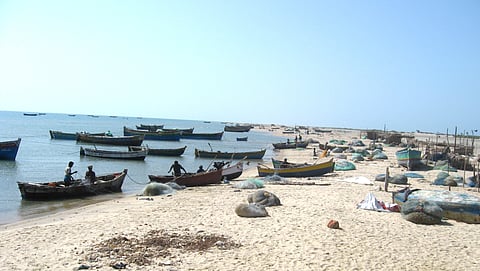
Coastal populations often face drinking water scarcity in India.
IWP Flickr photos.
High stress from variability in water availability stretches from the Red Sea coast and the Horn of Africa across the Arabian Peninsula to Pakistan. Other regions facing significant variability include Baja California in Mexico, northern Chile, Namibia, southern Mozambique, parts of Australia, Senegal, Mauritania, Kazakhstan, and some northern high-latitude areas.
Drought exposure is most pronounced along the African coast from Senegal to the Horn of Africa, extending through the Mediterranean region and southern Africa, including Namibia and South Africa. Similar patterns occur from the Arabian Peninsula to Pakistan and along the Caspian Sea coast, as well as in Western Australia, Baja California, and northern Chile.
Flood risks concentrate primarily around low-lying river mouths and delta regions. The most critical areas include the deltas of the Ganges, Brahmaputra, Meghna, Amazon, Irrawaddy, Indus, and Mekong rivers, where dense populations and fragile ecosystems increase vulnerability.
Water overuse forms a broad belt of stress extending from the Mediterranean region to the Caspian Sea and southern India. Other highly stressed areas include California, Baja California, Peru, Chile, Argentina, southwestern Africa, Australia, and the Bohai Sea coast.
High levels of eutrophication are typically found near densely populated or intensively farmed coastal regions. Major hotspots include Mediterranean Europe, several coastal areas in the United States and Latin America, and parts of Japan, China, and India, along with scattered regions elsewhere.
Stress related to inadequate drinking water services is highest in low income countries, with some middle income nations also affected. The problem is particularly pronounced just south of the Equator and across regions between and beyond the tropical zones.
Asian coastlines dominate the global map of exposure and vulnerability. Among the most affected countries are China, India, Bangladesh, Indonesia, South Korea, Japan, and the Philippines, where large populations live in densely settled coastal zones.
Population concentration is especially high in a few major coastal megacities where multiple water stressors converge, including scarcity, flooding, pollution, and sea level rise. Key examples include:
East Asia: Dense urban coastal belts such as Shanghai, Tokyo, and Seoul.
South Asia: Megacities, including Kolkata, Dhaka, and Mumbai.
South East Asia: Urban clusters around Jakarta and Manila.
Mediterranean and Middle East: Coastal cities such as Cairo and Istanbul.
West Africa: Lagos and other cities along the Gulf of Guinea.
South America: Rio de Janeiro, São Paulo, and Buenos Aires along the Atlantic coast.
These urban coastal regions face disproportionate pressure because rapid population growth intensifies demand for water while increasing exposure to environmental hazards.
Major coastal risk hotspots include Gujarat in India, Bengal across India and Bangladesh, Sumatra and Java in Indonesia, Mindanao in the Philippines, eastern China, and the Korean Peninsula.
Significant drought hotspots occur across the Indian subcontinent and eastern China, particularly in the Shanghai-Hangzhou to Tianjin corridor. Other notable regions include the Korean Peninsula, eastern India, the Persian Gulf and Red Sea coasts, Senegal, Gambia, parts of the Mediterranean, and several areas around the Caribbean Sea.
Flood risk hotspots concentrate around densely populated river deltas. The Ganges-Brahmaputra-Meghna delta ranks as the most prominent, followed by the deltas of the Mekong, Yangtze, Irrawaddy, Chao Phraya, Red River, Hai Yellow, Euphrates-Tigris, and Indus rivers.
Major hotspots of overuse occur in densely populated coastal areas of India and Pakistan, particularly around Gujarat and India’s eastern coast, as well as eastern China, the Korean Peninsula, the Mediterranean region, the Red Sea, and the Persian Gulf.
The most significant eutrophication hotspots lie along Asian coastal belts from Pakistan to Indonesia, including the Philippines, China, the Korean Peninsula, and Japan. Additional hotspots appear along the Mediterranean and North Sea coasts and parts of the Gulf of Guinea and Central America.
Hotspots for inadequate drinking water access overlap with several of the regions facing variability and eutrophication in Asia. Outside Asia, African coastal regions show a particularly high concentration of drinking water stress compared to other risk categories.
Livelihoods across India's coasts.
IWP Flickr photos.
Looking at the headcount of coastal zone human population facing risk for water stressors by country, China, India, and Indonesia stand out as being the most affected out of the ten top countries. Together they contribute 34% of global flood risk and 22% of global drought risk.
At risk people on the coasts worldwide
Varis, O et al. (2026) Mapping world’s coastal population facing water-related risks. Geography and Sustainability, 1 (4), 100411.
While the total coastal population is approximately 2.9 billion, the top 10 countries account for 49% of this population, and their share of people at risk ranges from 52% (overuse) to 70% (flooding).
The study thus finds that:
Flooding risk is the most concentrated stressor, with Asian megacities disproportionately exposed.
Overuse of water resources is widespread but still heavily skewed towards the top 10 coastal nations namely India, China, Indonesia, Pakistan, Nigeria, Bangladesh, Yemen, Egypt, Brazil and the Philippines.
Drought risk is less globally dominant but still critical in South and South-east Asia.
China, India and Indonesia top the population of the coastal zone and face the biggest stressors and risks due to vast populations, middle-income development levels, extensive surface areas of their coastal zones, and location along latitudes prone to climatic and hydrological stressors. In stark geographic contrast, African low-income countries top the ranking of the share of the population facing such risks.
The study argues that coastal communities face mounting water risks, and a detailed spatial analysis can greatly help in identifying who is the most vulnerable. This evidence can help policymakers and communities share responsibility for protecting the world’s most stress-prone coastal areas. The world’s coastlines tell a story of opportunity and vulnerability intertwined. They support thriving cities, global trade, and millions of livelihoods. Yet the same landscapes are under growing strain from environmental change and human pressure.
The mapping of global coastal water risks offers a sobering reminder that resilience cannot be built through infrastructure alone. It requires careful management of water resources, protection of ecosystems, and planning that places vulnerable communities at the centre. For countries like India, where population density and environmental stress meet along fragile coastlines, the challenge is particularly urgent. The choices made today about water use, urban growth, and coastal protection will determine whether these regions remain engines of prosperity or become frontlines of crisis.