- Topics
- Feature
- Opportunities & Events
- About
- Hindi Portal
- Data
- Topics
- Feature
- Opportunities & Events
- About
- Hindi Portal
- Data

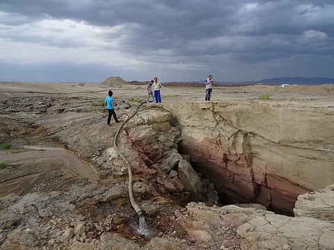
When we think of cities growing, we picture skylines climbing higher, roads spreading wider, and suburbs spilling outward. But across India, the real story may not be what’s rising, but that of what’s sinking instead. From Delhi’s crowded neighbourhoods to Kolkata’s wetlands and Himalayan towns like Joshimath, the ground beneath our feet is giving way, slowly in some places and alarmingly fast in others.
This is no longer just a scientific curiosity, it is a crisis with real consequences: collapsing houses, sunken roads, disrupted transport networks, and mounting economic losses. And much of this damage is of our own making. Groundwater over-extraction, unregulated mining, and unchecked construction are leaving invisible scars underground that eventually pull the earth downward.
A new review by Alimpika Gogoi, Girish Ch. Kothyari, and Atul Kumar Patidar explore just how deep this problem runs, literally. Their paper, “Ground Subsidence Monitoring in India using InSAR: A Review of Current Status and Future Prospects,” offers a sweeping look at this growing threat and shows how satellite-based monitoring, particularly Interferometric Synthetic Aperture Radar (InSAR), is revolutionising our ability to track and understand it.
Ground subsidence is the gradual or sudden sinking of the earth’s surface caused by the compression or weakening of soil and rock layers beneath. In India, this is driven by several factors like excessive groundwater pumping, large-scale mining, rapid urbanisation, and natural shifts in the earth’s crust.
The results are stark: homes and roads crack, railway lines deform, drainage systems fail, and saltwater seeps into farmland. These impacts threaten infrastructure, agriculture, and entire communities. A recent review highlights that over 1,596 cities worldwide are at risk, including Indian hubs like Delhi, Ahmedabad, Kolkata, and Varanasi, where sinking rates have been recorded at up to 25 millimetres a year. Even remote regions like the Teesta basin in Sikkim and Joshimath in Uttarakhand, both of which have seen sudden collapses, are now under close satellite observation.
These findings highlight the urgency of incorporating land subsidence data into city planning, groundwater regulation, and infrastructure development before the damage becomes irreversible.
Groundwater has long been treated as an infinite and invisible lifeline — but over-extraction is now one of the primary drivers of land subsidence in India. Unregulated pumping, particularly from deep aquifers, removes the water that supports underground soil layers. This loss of pressure causes compressible clays to collapse, leading to permanent sinking of the ground above.
InSAR satellite studies have confirmed what residents of sinking neighbourhoods have long suspected: we are literally pumping our way into disaster. Delhi has recorded deformation rates of up to 16 mm/year in multiple locations due to borewell proliferation and falling aquifer levels. Similar patterns are seen in Varanasi (30 mm/year), Ludhiana (24.7 mm/year), Sangrur (70 mm/year), and Ahmedabad (25 mm/year).
In Kolkata, decades of groundwater withdrawal have caused land subsidence near Salt Lake and Bidhannagar, worsening flooding during monsoon rains. In Punjab’s agricultural belts, the situation is even more severe — SBAS-InSAR measurements reveal deformation rates between 70 and 120 mm/year linked to irrigation pumping. This relentless drawdown may be buying short-term crop yields at the cost of long-term land stability.
Industrial areas are not immune. Hydrocarbon extraction in Dibrugarh and Digboi (Assam) and rapid infrastructure development near Cochin airport have also contributed to sinking ground.
Experts stress that this is not just a geological issue — it is a governance challenge. Without stricter groundwater regulation, improved recharge measures, and better integration of satellite data into policy, the invisible crisis beneath us will only deepen.
Traditional ground-based techniques for measuring subsidence, such as optical levelling or GNSS, are precise but expensive, labour-intensive, and limited to small areas. InSAR technology changes the game. By comparing radar images taken from satellites over time, InSAR can detect ground movement with millimetre-level accuracy across vast regions and in all weather conditions.
Advanced techniques like PSInSAR (ideal for cities with plenty of stable structures), SBAS-InSAR (suited for agricultural or vegetated areas), and SqueeSAR (valuable in mountainous terrain) are now enabling scientists to build time-series models that reveal not just where land is sinking, but how fast and why.
This technology provides India with a powerful, scalable, and cost-effective way to monitor subsidence — offering the data needed to inform urban planning, groundwater management, and disaster preparedness.
The review meticulously maps subsidence across India's geographies:
Northern India: Delhi NCR exhibits widespread subsidence linked to groundwater extraction. In Ghaziabad, subsidence has caused road and infrastructure damage, while Himalayan towns like Joshimath and Mussoorie have seen alarming sinking due to tectonic activity and unregulated development.
Eastern India: Kolkata’s Salt Lake and airport areas are sinking at 8–16 mm/year, primarily due to excessive groundwater withdrawal. In Jharia and Raniganj, coal mining has caused ground to sink by up to 120 mm/year.
Northeastern India: Assam and Sikkim show significant ground deformation linked to fault activity and hydrocarbon extraction. Digboi and Dibrugarh, oil-rich towns, are experiencing annual subsidence of up to 22 mm.
Western India: Ahmedabad and parts of Gujarat’s Kachchh region are undergoing seismic-induced deformation. Deformation rates in Kachchh are up to ±12 mm/year, worsened by the aftershocks of the 2001 Bhuj earthquake.
Southern India: Cochin International Airport is subsiding at 23.6 mm/year, largely due to building loads and flood-related soil saturation. In Andhra Pradesh, the Krishna Delta is seeing 5–6 mm/year of sinking due to aquaculture-induced groundwater imbalance.
The authors detail the multifaceted impacts of ground subsidence. Buildings crack or collapse, roads buckle, and drainage networks misalign, often leading to floods. In agricultural regions, compacted soil reduces productivity and encourages waterlogging. Coastal areas see saltwater intrusion, leading to freshwater contamination and crop loss. The human toll is significant — economic displacement, health hazards from sewage leaks, and fatalities from collapsing structures.
Land subsidence also poses a long-term ecological risk. It alters river flows, affects aquatic and terrestrial habitats, and may even accelerate carbon release from peatlands and marshes.
Despite technological advances, significant research gaps persist. Most Indian studies are site-specific and lack fault-wide deformation modelling. Remote regions often suffer from poor GNSS coverage, hindering accurate vertical deformation analysis. Furthermore, the role of complex fault interactions, fluid content in aquifers, or urban compaction remains under-researched.
The authors call for an integrated strategy that combines InSAR with ground-based data, seismic records, and hydrological modelling. They recommend:
Developing accessible, budget-friendly InSAR processing software.
Establishing a national geodetic monitoring network.
Encouraging the use of time series analysis for long-term monitoring.
Incorporating subsidence assessments into urban planning and disaster mitigation strategies.
Leveraging high-resolution SAR sensors and next-generation missions like ROSE-L to improve accuracy.
As India continues to urbanise and industrialise, the risks from subsidence will only intensify. Coastal vulnerability, erratic rainfall, unchecked construction, and groundwater depletion make subsidence a ticking time bomb that can undo decades of development.
What Gogoi, Kothyari, and Patidar’s review makes clear is that India now has the tools to act. With InSAR technology offering real-time, wide-area monitoring, the country can move from reactive repairs to proactive planning. But technology alone is not enough as institutional coordination, public awareness, and strong policies must come together to keep the ground beneath our feet stable and secure.