- Topics
- Feature
- Opportunities & Events
- About
- Hindi Portal
- Data
- Topics
- Feature
- Opportunities & Events
- About
- Hindi Portal
- Data
Thembang, a small village in the West Kameng district of Arunachal Pradesh is inhabited by the Thembang Monpas, a sub-tribe of Monpas. The village lies in the Eastern Himalayas and gets a mean annual rainfall of more than 1500 mm (India Meteorological Department, 2019). In the last few years, the village springs have either dried up or their discharge has reduced due to land use and land cover changes.
Spring in Monpa language is referred to as ‘Ri’. Currently, there are two springs inside the village on which people depend for their domestic water consumption: Jongjong Gapsa Ri and Labtsesjab Jongtangpu Ri. Of these, Jongjong Gapsa Ri is the major spring source used by all the households of Thembang.
The history of Thembang dates back to the 4th century BCE, and Jongjong Gapsa Ri is considered to be its major spring source ever since people first settled here. Initially, the whole village was located in a Dzong (fort) constructed in the 4th century BCE. A water collection point locally known as Ri-Grangnang was built near the bottom of the stair approaching the northern gate of the Dzong.
Ri-Grangnang was a building structure with a prayer wheel inside, which was propelled by the force of the water discharged through an inlet wooden channel. The villagers collected water from this structure through an outlet created using another wooden channel. The water to Ri-Grangnang was harvested from the Jongjong Gapsa Ri.
Until 1984, the entire Thembang village used to fetch water from Ri-Grangnang. But by the beginning of the 21st century, due to a decrease in discharge of water and an increase in dependency on Jongjong Gapsa Ri, the Public Health and Engineering Department (PHED) had to look for alternate sources of water for the village. A temporary water supply from the source of Labtsesjab Jongtangpu Ri to the village was made in 2008-09 and in 2011 a permanent storage tank was constructed.
For the villagers of Thembang, Jongjong Gapsa Ri is an important water body. Its source is located in a ‘sacred loo’. In Thembang, a sacred loo is a holy piece of land for the family that owns it and is directly connected to the family’s economic status and wellbeing.
Any activity that desecrates the place like logging, pruning, littering, urinating, cooking meat and onion and construction of structures is believed to adversely impact the family’s wealth. The water from a sacred loo is used for rituals, therefore the villagers undertake regular cleaning and do rituals for the purification of the place to appease the ‘Nag’ who resides in it.
The source of Jongong Gapsa Ri is surrounded by oak trees (Quercus sp.). Oak is an important tree for the Monpas. Dried oak leaves are used as manure in agricultural fields, so logging of this species is prohibited in Thembang.

Sacred loo, source of Jongjong Gapsa Ri (Image: Manisha Kumari)
Through these traditional beliefs and practices, the villagers of Thembang have been able to protect the source of Jongjong Gapsa Ri. But these regulations do not apply to the entire catchment area. Activities of logging and clearing of land for horticulture have been taking place in the catchment area of the spring.
Trend analysis shows how agricultural land and settlements have increased and forest areas and water bodies have decreased over the last seven decades. The trend analysis was conducted through group discussion and key interviews with village leaders and the water user group of Jongjong Gapsa Ri. The analysis threw light on the changes in forest cover, agricultural land, population and water resources in Thembang in the last 70 years.
“The discharge of Jongjong Gapsa Ri has decreased significantly in the last 20 years due to degradation and overexploitation in the springs’ catchment area," says Tsorgan, a gaon burah (village leader).
Collection of timber and forest clearing for horticulture activities are some of the land-use changes that took place in the area during the last decade. The beliefs and practices for spring sources are limited to the community’s understanding of the potential catchment area of the spring which does not overlap with the catchment area delineated through geological mapping.
“The decline in spring discharge in Thembang compelled the villagers to shift from Jongjong Gapsa Ri to Labsestjab Jongtagpu Ri. The availability of other water sources masked the ongoing threats to the spring sources of the village. The collection of timber for commercial purposes from the village forests was banned by the community in the year 2000, but this could not offset the environmental damage already done by the clearing of forests,” he adds.
The solution provided by the PHED through changing the water source has been effective in meeting the village’s water demand. But this does not address the decline in discharge in the Jongjong Gapsa Ri. At present, from the 69 households in Thembang village, of which 19 households are dependent on Jongjong Gapsa Ri.
The World Wide Fund for Nature (WWF) India with the technical support from the People’s Science Institute (PSI), Dehradun under the National Mission on Himalayan Studies program started working with the communities to help conserve their water sources. After conducting water dependency surveys, geological mapping and monitoring the spring discharges, potential recharge area of the spring with recharge measures were suggested.
A water user group comprising of 19 households was formed in 2019, with support from WWF-India and PSI. The group formulated the rules and regulations for the spring source and also initiated recharge activities in the catchment area.
Water user group of Jongjong Gapsa Ri (Image: Manisha Kumari)
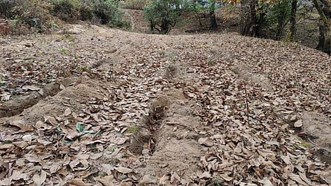
With the support from WWF-India and PSI, the villagers have constructed 600 trenches in the catchment area and are now developing a nursery of local water-retaining plant species to be planted before the monsoon of 2021.
The activities for revival of Jongjong Gapsa Ri have been possible by delineating the recharge area using hydrogeological mapping, recording the seasonal discharge changes and respective household-level water usage and incorporating existing traditional beliefs and practices.
The community’s effort to grasp the various facets of the issue and mobilize themselves is essential to develop effective interventions. Through this adaptive strategy of scientific and traditional knowledge systems, Jongjong Gapsa Ri is being rehabilitated. The villagers, now trained in taking discharges and rainfall readings are continuously monitoring the discharge of the spring and are also enthusiastic about reviving other threatened spring sources.
Manisha Kumari is currently working as a Project Officer in the Western Arunachal Landscape team of WWF-India. Her work revolves around strengthening the traditional livelihoods of local communities as a part of community-based conservation.
Pema Wange has been working in Arunachal Pradesh since 2004. He is currently Senior Project Officer in the Western Arunachal Landscape team of WWF-India. He has been working on Community Conserved Areas (CCAs), Community Based Tourism (CBT), high altitude wetland conservation, red panda conservation and climate change.