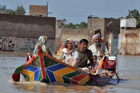
 Flooding forced millions of Pakistanis to flee their homes in July and August 2010.
The summer of 2010 was different. In July and August, rain fell over most of Pakistan and persisted in some places for weeks.
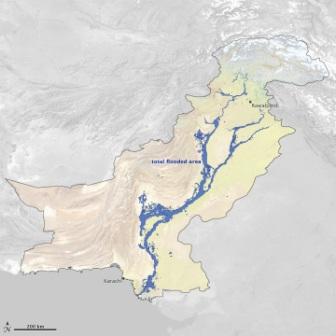
Rivers rose rapidly, and the Indus and its tributaries in the northern part of the country soon pushed over their banks. As the surge of water moved south, it swelled the Indus in Pakistan’s central and southern provinces. Then the problems started compounding. In Sindh, a dam failure sent the river streaming down an alternative channel west of the valley. The resulting floodwater lake which merged with existing Manchhar Lake spread over hundreds of square kilometers.
 Floods covered at least 37,280 square kilometers (14,390 square miles) of Pakistan at some time between July 28 and September 16, 2010. Relief agencies used maps derived from satellite data to direct aid to many of the victims and to plan recovery efforts.
Even after the monsoon rains subsided, waters retreated much more slowly than they had advanced. Months after the rains stopped, crops, homes, businesses, and entire towns were still submerged. In some places, there were few means of water dispersal beyond waiting for it to evaporate.
The U.S. Agency for International Development estimates that the Pakistan floods affected more than 18 million people, caused 1,985 deaths, and damaged or destroyed 1.7 million houses. It was perhaps the worst flood in Pakistan’s modern history.
Relentless Rain
The Asian monsoon is one of the world’s most studied weather patterns. Sunlight warms the land surfaces of Central Asia, and the warm surface air rises into the atmosphere. This updraft draws in cooler, moister air from over the Indian Ocean. The Himalayas supercharge this convection process by blocking air masses from migrating into central Asia. Instead, the moist air masses rise, cool, and condense the water into rain.
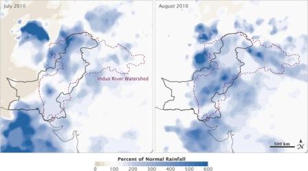
In 2010, this pattern went awry over Pakistan. Over and over again, the rainstorms dwarfed the heaviest rainfall events from the previous, more typical summer. July rainfall in Peshawar, for instance, was up 772 percent from normal, according to the Pakistan Meteorological Department. August rainfall in Khanpur was up 1,483 percent.
 The 2010 floods in Pakistan were caused by extremely high rainfall in the Indus River watershed during July and August. These maps show the satellite estimates of the difference in rainfall between 2010 and the long-term average for the region.
The relentless rain had a handful of causes. For one, the global La Niña event which drenched Australia and other Pacific and Indian Ocean locations in late 2010 and early 2011 actually started around the time of the 2010 monsoon. La Niña warms both water and air masses, increasing the amount of moisture that can be carried in the atmosphere.
While La Niña increased the chance of rain events, it did not necessarily increase the intensity and unusual persistence. Instead, some meteorologists speculated in late 2010 that the jet stream might have set the stage for floods in Pakistan, as well as the summer of drought and fire in Russia. Some noted in science meetings that the jet stream had taken on an unusual pattern, stretching down over the Eurasian continent and stagnating the weather patterns.
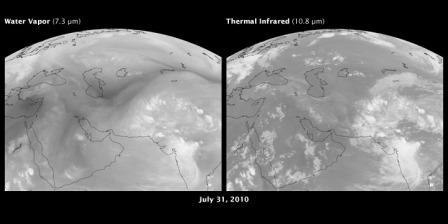
 A long-lived high-pressure system north of the Black Sea trapped hot air over Russia in 2010, and triggered heavy rainfall over Pakistan. This image shows water vapor in the atmosphere (left) and thermal infrared emissions of the Earth (right). Water is bright in the left image; on the right, dark areas are hot (desert in mid-day) and cold areas (cloud tops) are white. The animationshows the interaction between high-level flow of water vapor and the dynamics of clouds.
In a subsequent study (in press) using NASA satellite data, scientists William Lau and Kyu-Myong Kim of NASA’s Goddard Space Flight Center found a connection between the wildfires and floods. The Russian heat wave and wildfires were associated with a large-scale, stagnant weather pattern in the atmosphere known as a blocking event that prevented the normal movement of weather systems from west to east. Hot, dry air masses became trapped over large parts of Russia.
The blocking also created unusual downstream vortices and wind patterns. Clockwise atmospheric circulation near the surface brought cold, dry Siberian air into the subtropics, where it clashed with the warm, moist air being transported northward with the monsoon flow. The result was torrential rain in northern Pakistan.


