- Topics
- Feature
- Opportunities & Events
- About
- Hindi Portal
- Data
- Topics
- Feature
- Opportunities & Events
- About
- Hindi Portal
- Data

Deltas around the world are under threat. Recent research shows that around 85 percent of the deltas of the world are shrinking.
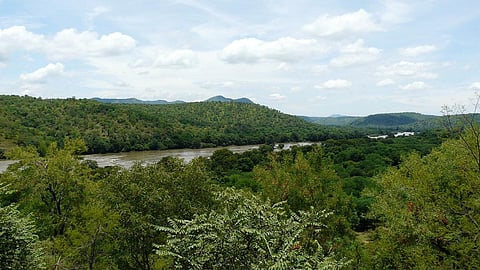
Deltas are wetlands that are formed when rivers empty their water and sediments into the ocean, lake, another river or very occasionally, on land.
A river moves slowly as it nears its mouth, or end and this causes sediments and solid material that it carries downstream by currents, to fall to the river bottom [1]. The slowing velocity of the river and the build-up of sediment breaks the river from its single channel as it nears its mouth to form a deltaic lobe that includes a network of smaller, shallower channels, called distributaries, that emerge like branches from the mainstream of the river [1].
The heavy and course matter that the rivers carries settles first in the deltaic lobe while the smaller, finer sediments are carried farther downstream and deposited beyond the river's mouth [1]. This material is called alluvium or silt and is rich in nutrients that help small microbes and plants or the primary producers in the food web to grow. Accumulation of more and more silt leads to land formation, the delta, which extends from the mouth of the river into the body of water into which it is emptying [1].
Deltas are formed in three different ways, based on the river's discharge, the characteristics of the basin, and the solid load and include:
River-dominated deltas: The deposits and landforms created by flowing rivers create many channels as the river travels into the ocean, and sediment is deposited along those channels. These deltas are known as "birdfoot deltas".
Wave-dominated deltas: Are formed in micro-tidal coastal regions where the coast has a steeper gradient and the energy from the waves redistributes sediment forming a triangle-shaped delta.
Tide-dominated delta: River sediments are carried seaward at low tide. As a result the river mouth appears clear of sediment (estuary), but sediments are deposited as underwater longitudinal bars at the river's mouth. The deltas of the Mekong and Ganges-Brahmaputra river systems are examples of this type of delta [2].
Deltas have a fan shape, with a convex side towards the sea and are divided into:
Delta plain (topset): It is the part that is above water, divided into the upper delta (where fluvial processes take place) and lower delta (influenced by tides).
Delta front (foreset): It is the outer limit of the part above water.
Prodelta (bottomset): The part found under the water [2].
River deltas are one of the most biologically productive sites and their rich soil harbours a large variety of plants and animals. River deltas support fish nurseries, fisheries, crustaceans, forests and crops such as tea and rice. Ecosystems like wetlands and mangrove forests depend on a stable river deltas. Animals like birds, insects and sometimes even large predators rely on the delta ecosystems [1].
Deltas absorb runoff from floods (from rivers) and storms (from lakes or the ocean) and reduce the impact of pollution by filtering water as it slowly makes its way through the delta's distributary network [1].
Human induced land use changes, urbanisation, infrastructural development such as dams, canalisation, flood control measures, shift in agricultural practices, over extraction of groundwater etc and climate change can alter river deltas negatively affecting their ecosystems and the biodiversity that these ecosystems harbour [3].
Over-abstraction of freshwater from river deltas distorts the natural equilibrium of recharge and discharge, resulting in depletion and salinisation (Rising salinity due to sea-level rise) and decline in freshwater flows from upstream in the river deltas.
A study titled 'Assessing the impact of groundwater abstractions on aquifer depletion in the Cauvery Delta, India' published in Agricultural Water Management assesses the impacts of stresses such as groundwater pumping, changing cropping patterns, and saltwater intrusion on groundwater resources in the Cauvery Delta in Tamil Nadu.
The Cauvery river basin is one of the largest river basins in South India and covers an area of 81,155 km2. The basin is shared by the states of Karnataka (42.23 percent), Kerala (3.53 percent), Puducherry (0.2 percent), and Tamil Nadu (54.04 percent) with Karnataka and Tamil Nadu sharing the largest sections of the basin. The Cauvery river drains into the Bay of Bengal after traveling around 800 kmts.
The 2000-year-old Grand Anicut barrage is the beginning of the delta where the Cauvery splits into several branches. The northern branch is the Coleroon river, which is the north boundary of the delta while the other three branches include the Cauvery and Vennar rivers, and the Grand Anicut main canal forming the western boundary. The command areas of the branches consist of dense canal networks and are referred to as the Old Delta (Cauvery command area), Vennar Delta (Vennar command area) and the New Delta (Grand Anicut command area), respectively.
The Cauvery Delta of Tamil Nadu has been affected by reduced freshwater inflow, floods, and increased salinity. Rainfall in the region has become more erratic and uncertain leading to changes in river flow regimes and a lower surface water availability. The delta region experiences diminished surface water from the southwest monsoon and waterlogging caused by the more irregular and intense north-east monsoon; changing land use and cropping patterns due to salinity in the region, which has forced farmers to shift from rice cultivation to aquaculture, and a decline in canal water forcing farmers to shift from two short-duration rice varieties into a single, extended one. Groundwater models were applied to analyse field observations as well as the feedback from farmers.
Canal flows are reduced, rains are more irregular, and groundwater extractions are increasing. Deeper aquifers show a decrease in groundwater levels with a cone of depression in the Vennar and New Deltas. The tail end of Grand Anicut Canal or the central part show a continuous decline in groundwater levels, depletion of groundwater storage, and increased seawater intrusion.
The transient model indicates that seawater intrusion has increased three times from 1990 to 2019 thus leading to deterioration in the groundwater quality.
Groundwater levels in shallow aquifers are decreasing rapidly and farmers also are reporting of a drying delta and the need for abandoning of shallow wells for deeper boreholes. Farmers drill deeper wells because of the insufficient reach to the surface water during the annual dry period, while in the coastal area, the use of shallow wells for irrigation is almost nil, because of salinity.
The study reveals that deeper aquifers are being heavily exploited every year and the increase in pumping coincides with the dry months of pre-monsoon summer and also during the drought years.
Thus the aquifers in the region have already reached the maximum stage of groundwater development and are overexploited, with abstractions exceeding the rate of replenishment.
The paper warns that if the current abstraction regime continues, groundwater levels will continuously decline, which will result in large depletion of groundwater storage and induced seawater intrusion. The study recommends reduction in abstraction by 50 percent for the deeper aquifers and recharge for the shallow aquifers.
The study concludes by recommending: