- Topics
- Feature
- Opportunities & Events
- About
- Hindi Portal
- Data
- Topics
- Feature
- Opportunities & Events
- About
- Hindi Portal
- Data
What are floods, why do we have floods at all? Jeevitnadi Living River Foundation, in this third video Part 1 & 2: Dams and floods released on 25th June 2021 from the series on 'Everything about floods', highlights the role that dams can play in managing floods and the challenges faced at the policy and planning level to manage floods.
Watch Part 1 of the video: Dams and Floods by Jeevitnadi in Marathi here
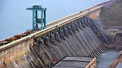
In the earlier videos, we talked about the journey of a river from rainfall to flow and then to floods. Dams are an important part of this process and have an important role to play in the journey of a river from flow to floods. While we tend to think of dams as large structures constructed to store water and control floods, do dams really help in reducing floods?
In Maharashtra for example, dams were not constructed to deal with floods, but mainly for irrigation. Even water for industries and drinking was added later. Dams in Maharashtra also do not have gates to control and manage floods. For example, in states such as Bihar, Assam, Uttar Pradesh that experience frequent floods, dams are built for flood management and some space is maintained to absorb floods. Thus when floods occur, this space is filled and then the water is released later. This is not the case with Maharashtra, Gujarat and Karnataka as they traditionally do not experience floods.
This often creates a dilemma for officers who manage dams and its water storage capacity in Maharashtra. We do not have flood absorption capacity. Officers face problems, as as there is pressure on them to use dams mainly for storage while at the same time control/manage floods . If there is too much storage, then water needs to be released leading to floods. If less water maintained in the dams, then there is no water left if the state experiences droughts. We as citizens should understand these dilemmas that they face.
We have now developed some understanding of the situation over the last fifty years since the state has a lot of dams. A Reservoir Operation Schedule has been developed over the years wherein steps are undertaken to deal with the evolving situation by planning for every 15 days, when excess of water is released and water stored according to the water level and time by taking into consideration the evolving situation. We thus have guidelines made to plan storage and prevent floods gradually.
However, to develop a better understanding of dams to cope with floods, we need regular monitoring systems in place and better data and methods to help in real time data analysis to predict floods earlier on. This too gets complicated as larger river basins such as the Krishna, Godavari have multiple dams or chains of dams making analysis difficult.
This needs better management and communication at the central, state, district, local and community levels and use of new and advanced technologies to predict and manage floods. Climate change is further adding more challenges as episodes of extreme rainfall, floods, droughts, cloudbursts and landslides are increasing in the state.
Watch Part 2 of the video: Dams and Floods by Jeevitnadi in Marathi here
The earlier video highlighted the role of dams in controlling floods. However, once rivers get flooded, we have to consider not only the river basin, but the dam or chain of dams constructed on the river basins and all stakeholders involved in managing floods right from government officials at the centre, state, local levels to communities and people at the ground level experiencing and bearing the brunt of floods.
It is not possible to manage floods at the individual level. We need infrastructure that involves different institutions and organisations that need to work together in a coordinated fashion to deal with floods. A range of institutions are involved in managing floods right from the Water Resources Department that needs to work with the Indian Metereological department, Panchayat Raj Institutions, Revenue Department, Home Department and also the police department, in times of emergency.
Flood control officers in the Ministry of Water Resources provide information to Municipal Corporation, Zilla Parishad, tehsil, villages and home department in flood prone areas for provision of resources, medical care etc in emergency situations. Although in the case of small floods, it might not be necessary to involve the Ministry, all in the chain need to be informed on what is happening at the ground level.
We also need modern technology and real time flood forecasting is now used to look at what happens at watershed level and data is collected regularly to evaluate the situation in flood prone areas. All these messages go to the data centre, where the evaluation of the watershed is done and flood intensity predicted. This has been started in the Krishna basin and can be even done for Karnataka for the Almatti dam which can help in lessening the intensity of floods by working together.
Rainfall, river discharge, water level data must be available and analysed with the help of new software, so that flood control officials get this information early. Currently we do not have very efficient flood control mechanisms. Reservoir operation procedures are not followed properly. Also, flood zoning is not only an engineering matter, it has a number of economic, social, cultural and political dimensions that makes implementation difficult.
And challenges are increasing day by day. While we can look at the last 100 years data, this might not be useful to predict the new challenges that are arising due to climate change. For example, flood prone areas are increasing due to rise in events such as cyclones, cloud bursts in Maharashtra.
Increasing human interventions and encroachment on water bodies such as rivers, ponds, lakes, streams are also to be blamed for increase in the intensity of floods. We have restricted the flow of rivers while all water bodies such as streams, lakes, ponds are gradually disappearing due to encroachments in urban areas. This worsens the impacts of floods. For example, the 2019 floods in Sangli, Kolhapur and Satara and the recent floods in Pune worsened as the water did not have any place to percolate due to massive encroachments in the area leading to significant loss of lives and property.
Prevention of this unchecked and uncontrolled urbanisation and encroachment of water bodies in urban areas is an urgent necessity to cope with the growing impacts of climate change and increasing floods in the future.
Please view earlier episodes on floods here: