- Topics
- Feature
- Opportunities & Events
- About
- Hindi Portal
- Data
- Topics
- Feature
- Opportunities & Events
- About
- Hindi Portal
- Data
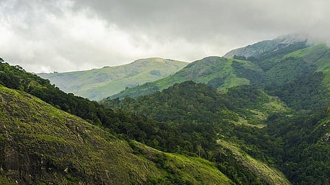
Community scientists, with the assistance of professional researchers, have developed a meteorology-based landslide prediction system for India’s Western Ghats mountain range, according to a paper published earlier this year. Called “Satark,” the model is capable of predicting landslides along India’s mountainous southwestern coast a day in advance with an accuracy of 76.5%.
Thirteen out of 15 authors of the paper are “community scientists” with non-meteorological backgrounds, including banking, journalism, mechanical engineering, and microbiology. They are part of Centre for Citizen Science (CCS), a volunteer-led nongovernmental organization based in Pune, India.
“In 2014, a mudslide occurred in Malin [in the Pune District], and the entire village was buried under debris. Around 150–200 people died. And when we checked past records, we saw that such events are common to Malin and even generally across the Western Ghats,” said J R Kulkarni, lead author of the paper. Kulkarni is a trustee at CCS and was previously a meteorologist with the Indian Institute of Tropical Meteorology (IITM), Pune, and the World Meteorological Organization.
Scientists found that meteorological conditions like rainfall, as well as geologic factors like slope, soil type, and land cover, were common to such events. “In a non-earthquake and non-cyclone scenario, rainfall is the only trigger,” Kulkarni pointed out.
Prior to collaboration, scientists and CCS worked independently to monitor rainfall patterns in the Western Ghats. Researchers gathered rainfall data from the Tropical Rainfall Measuring Mission (TRMM) and radar data for two points in the Western Ghats: the city of Mumbai and the state of Goa.
The model also relied on weather forecasts from the Indian Meteorological Department (IMD). The paper lists 54 rainfall-triggered landslides in the Western Ghats between 2000 and 2016 and notes that the highest frequency of landslides occurs in July and August—peak monsoon months in India.
Meanwhile, volunteers at CCS identified landslide-prone sites in the Western Ghats. They also worked with scientists to identify rainfall thresholds that could trigger landslides.
“We [community volunteers] visited the landslide-prone areas, and with the help of meteorologists [like Kulkarni] and geologists, we were able analyse our hypotheses with data and technology and develop a prediction system,” said Mayuresh Prabhune, one of the authors of the paper and a journalist by profession. Prabhune is also the secretary at CCS.
Together, the two groups tracked rainfall intensity and duration. In India, not all locations have weather monitoring stations to track such patterns, and this is where communities help fill a crucial gap in both monitoring and preparedness.
The team distributed rain gauges to around 50 people across the Western Ghats and also provided training on how to take measurements and read scientific literature. With these tools, communities could measure and assess rainfall data on their own.
“They don’t have to wait for data from IMD or anyone else,” Prabhune said. They can also take precautionary measures if the data they are tracking show threshold breaches for a continuous period.
“When rainfall begins in the monsoon season, we ask people to keep watch. And if intense rainfall persists for 3 days, they know that it is now the ‘alert stage,’” Kulkarni explained. The next stage is “warning,” wherein rainfall breaches thresholds for the next 3 days and the risk of landslides is greater than 90%. Once this stage is reached, residents are encouraged to temporarily move to safer locations.
The team at CCS provides alerts to a broader audience via a website, social media, and messaging platforms like WhatsApp.
In many instances, “taluka [local administration] officials have contacted CCS for information on rainfall and landslides,” Prabhune said, pointing to scope for collaboration between communities, scientists, and policymakers. The strength of the Satark model, he continued, is that because local people are already involved in the scientific studies and measurements, the task of spreading awareness is reduced.
Climate change is intensifying the need for a landslide prediction system based on meteorology, said Roxy Mathew Koll, a climate scientist with IITM. Both the frequency and intensity of cloudburst and extreme rainfall events have increased in the Western Ghats, he said, and although the IMD has a system to monitor and forecast weather events, “being a national agency, it may not be always feasible to have their products cater to remote regions at a very local level.”
Incidences like landslides and river floods are not monitored single-handedly by any meteorology department and require interdepartmental and inter-ministerial cooperation and data sharing. “This is where citizen science networks can play a major role.”
Also, Koll added, incidences like landslides and river floods are not monitored single-handedly by any meteorology department and require inter-departmental and inter-ministerial cooperation and data sharing. “This is where citizen science networks can play a major role,” he said.
Other community-led rainfall measurement efforts (like the Meenachil River – Rain Monitoring project in Kerala) have also demonstrated how communities, and school students in particular, can fill crucial gaps in areas like flood preparedness merely by tracking rainfall and water levels.
Satark is a “an interesting decision-making system” based on simple rainfall thresholds, said Rajeevan Madhavan Nair, former secretary of the Ministry of Earth Sciences, India. Overall, he added, it is “an excellent initiative to involve people to do socially relevant research work.”
Noting how measuring rainfall is often part of school syllabi but rarely put to use, Prabhune said that “even school students are very enthusiastic to take rainfall measurements. All you need is an interest in science.”
As the next step, Koll suggested having a set of guidelines to make such monitoring activities uniform across India. “Quality-controlled data from calibrated rain gauges can go back to IMD and can be used for research and forecast purposes,” he said.
The article was first published by EoS, Science News by American Geophysical Union here
Citation: Pardikar, R. (2022), A community-led landslide prediction system in India, Eos, 103, https://doi.org/10.1029/2022EO220269. Published on 7 June 2022.
