


New satellite images from NASA show the extraordinary scope of the continuing disaster in Pakistan, where thousands of square miles of land remain submerged two months after the country was hit by catastrophic flooding.
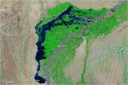 A satellite image captured last week shows flood waters lingering in Sindh Province and Manchhar Lake at twice its normal size.
An image from October 2009 (below) shows the Indus River during typical conditions, a thin ribbon of blue winding through irrigated land in Pakistan’s Sindh Province. This August, torrential rains caused the river to overflow its banks, wreaking havoc on towns and cities and destroying vast swaths of wheat and other crops.
An image from mid-October shows the river flowing normally. But in western Sindh Province, a vast floodwater lake lingers and Manchhar Lake remains twice its normal size.
According to a recent United Nations report, nearly 17,000 square miles of land in the province remains underwater, with more than one million people displaced in temporary camps, unable to return home. Health organizations fear the stagnating water will breed malaria-bearing mosquitoes.
“Seeing the devastation first hand and speaking with flood-affected families confirmed the astonishing reality of a continuing emergency for millions of people,” Rauf Engin Soysal, United Nations special envoy for assistance to Pakistan, said during a visit to Sindh on Wednesday.
Click here to read the entire article


