Dr Partha J Das, Aaranyak, talks about the impact of the 2012 floods in Assam and how the structural measures taken by the Government, have not been enough
Background
The north-eastern region of the country receives a large share of the summer south-west monsoon's rainfall, that usually lasts between June to September, in comparison to rest of the country. When the monsoon winds, make its way over Assam, the Brahmaputra swells manifold, as do its tributaries. And the impact, the resultant floods cause, is devastating.
Assam has always been prone to floods, but the Great Earthquake of 1950, led to massive changes in the topography and the Brahmaputra valley has, thereafter, been seeing increased devastation, due to floods (Centre for Natural Disaster Management, Assam, date not specified). Experts say the river has become more unstable after the earthquake and the shifting of channels and erosion have turned more severe and frequent. With more than 40 percent of its land surface susceptible to flood damage, the total flood-prone area in the Brahmaputra valley is 32 lakh hectares, which accounts for 9.6 percent of the country's total.
The unique environmental setting of the basin vis-a-vis the eastern Himalayas, highly potent monsoon regime, weak geological formations, active seismicity, accelerated rates of erosion, rapid deposition of silt along channels, massive deforestation, intense land use pressure and high population growth especially in the floodplain belt, and adhoc temporary measures of flood control, are some of the dominant factors that caused and/or intensify floods in Assam (Goswami, 2000).
Could there be other reasons, too?
The Brahmaputra valley has seen major floods post the 1950 earthquake, in the year 1954, 1962, 1966, 1972, 1974, 1978, 1983, 1986, 1988, 1996, 1998 and 2000 (Goswami, 2000). But the floods this year (2012), are said to be the worst ever in 10 years.
Experts are of the view, that the damage caused by the Brahmaputra has multiplied after the fifties, which also coincides with the time, embankments on the Brahmaputra were built by the Government to "contain" the flood waters.
There are a total of 449 embankments in Assam covering an area of about 4,459 km of stretch. While the state water resource department had already identified 950 km of embankments as extremely vulnerable, about 2,390 km stretch of the total length of embankments have been identified as vulnerable.

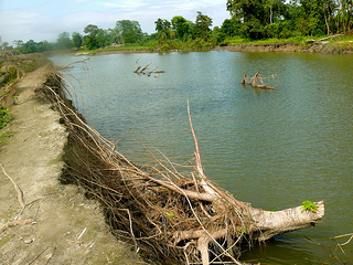
A tree uprooted as the Brahmaputra finds its way breaching the Sisi-Tekelefuita embankment also known as the the Sisi dyke
Photo courtesy: Dr. Partha J Das
The impact is far reaching…
As per data from the Assam Disaster Management Authority (ASDMA), around 23 lakh people across Assam and 11 districts have been severly affected, by the onset of floods during the latter half of June 2012. A total area of 1 million hectares has been hit by the flood and landslides. In all, twenty-one out of the twenty-seven districts in the state have been affected by the flood.
As per UNDP Situation Report-2 on the flood and landslide in Assam, as of 14th July, a total number of 109 people, including 70 children, have died due to the floods; in addition, 16 people including 5 children have been victims of landslides and an estimated 17 persons are missing. The floods devastated 2715 roads and hundreds of bridges making communication extremely difficult.
At least 560 animals, including 14 one-horned rhinos, have perished in Kaziranga (a UNESCO World Heritage Park) due to the floods this year. The park, located on the edge of the Eastern Himalayas, and a biodiversity hotspot, has been flooded since June 26, and within a couple of days, nearly 80 per cent of its 430 sq km area was inundated, with only the natural and artificial highlands spared, which was where the animals fled for shelter. The situation in other wildlife sanctuary areas including Dibru-Saikhowa and Manas was no better.
In the largest river island of the world - Majuli, also the seat of Vaishnavite culture, floodwaters submerged more than 80 villages in the island, affecting over a lakh of people compounded by massive erosion eating away vast tracts of the island’s already-receding landmass. Floodwaters also entered the island through the breached section of the embankment at Sonowal Kachari in Upper Majuli, inundating several villages and threatening the very existence of the island. People have been rendered homeless and excessive siltation after the flood has forced people in the area to shift their homes to other locations. Measures by authorities to protect Majuli from floods and erosion have not done much good.
Internal migration not a new phenomenon
Despite knowing that the river banks see rise in water levels every year, the communities living along the river seem to be losing confidence. Myriad reasons including changing patterns of monsoons, the opening of floodgates of countless dams upstream, the removal of river-bed rocks for construction work across the north-eastern region has exacerbated the situation.

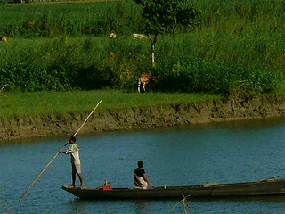
Scores of people have left their villages as agriculture might not be possible in these places in the near future
Photo courtesy: Dr. Partha J Das
The frequency and scale of destruction the communities are now experiencing have made them lose faith in depending completely on agriculture in the flood plains. They are increasingly migrating to other states in search of better livelihood options. Many work in states of Kerala and Karnataka, as daily wage labourers.
In all, the floods this year left a total of 2.55 lakh hectares of cropland affected. With significant loss to livestock, most communities dependent on agriculture and fisheries, are facing unprecedented ordeals.
Are embankments really an answer?
On 27th June, Nalbari district had unabated flow of water coming in, through breaches at 5 points along the embankment on the Borolia river at Larma Gaurhati. Though the embankment is located in Kamrup, the waters swamped a significant stretch of land in its close neighbourhood, leaving a huge number of villages in both districts submerged for 7-10 days. About 15 households were devastated in Kamrup, while the water-logging brought life to a standstill in about 12 villages in Barbhag block in Nalbari.
Barsimalua, a low-lying and one of the worst affected villages in Barbhag block, had water for longer stretch of time. Mostly inhabited by farmers and fishing communities, people lost their livelihoods after their crops were inundated and are finding it difficult to start afresh. Elders of the villages say that the floods that came 40-50 years back were not as bad as they are now and they used to inundate areas uniformly. But now, the case is not so after the embankments have failed to serve their purpose.
In another incident, the Sisi- Tekelefuita embankment or the Sisi Dyke that extends to more than 100 km starting from upper Dhemaji district and continues up to Majuli, had a similar story to tell. The embankment had played an important role in protecting thousands of people on the north bank of the Brahmaputra for about last 50 years.
This year, however, the embankment had two important breaches - at Bedlang and Namdang villages. In many places, the status of the embankment and its maintenance is very poor, which is the main reason attributed to the breach and collapse in many places. “The villagers had warned the authorities, including Government bodies when they identified the possibility of the breach, but this was ignored. This shows the lack of preparedness on part of the Government”, remarks Dr. Partha J Das, Aaranyak.
The villages inundated after the breach have been facing the consequences. Not only have the people been rendered homeless but also it has ruled out any hope, of coming back in the near future as huge stretches of agricultural land have been left covered with sand, rending them useless for agriculture. Dr. Partha Das commented that the impact of such displacement has grave sociological implications as people lose their local livelihoods and have to move to new places, where they need to start life from scratch. The Government does not even consider these families for compensation. They are full of anger and discontent and the possibility of this rage turning ugly cannot be ignored.

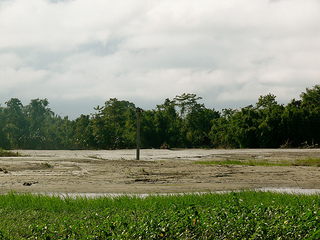
Huge expanse of agriculture land is deposited with sand
Photo courtesy: Dr. Partha J Das
Forty-two breaches in the embankments involving the Brahmaputra and 14 other tributaries in 14 districts this year, certainly throws up the question as to whether these structures are really effective.
Is living with floods an answer? Are there other solutions?
The floods are an annual disaster, though the scale might vary. The local people have adapted themselves well, to the loss they incur year after year; so are there long-term solutions we are not exploring?
The communities that face the floods year after year, in their own capacity have been implementing their traditional wisdom and early warning systems to reduce the risk during floods. Over the centuries, the Mishing tribal group in Majuli and other parts of the upper stretch of the Brahmaputra has developed the elevated chang ghor, a bamboo house on stilts that can be dismantled or quickly restored after a flood surge. Also, many people in the flood-affected areas are forearmed with boats, adapt or diversify cropping systems or practice mixed cropping (Hazarika, 2006). But that does not imply that they could be left to their own devices. The Government’s intervention has always been skewed and centered only on structural measures, mainly embankments, along with bamboo screens, concrete spurs and porcupines and others.
However, technology no matter how expensive or efficient cannot prove to be of any help, without a well-drawn policy that can ensure its implementation. A comprehensive policy that looks at the impacts of floods and subsequent erosion, on the land and its people, while acknowledging traditional flood management practices is the need of the hour.
View photos of 'Floods in Assam 2012' on Flickr
References
UNDP Situation Report 2 on the 2012 floods in Assam, 2012
Hazarika Sanjoy, (2006) “Living intelligently with Floods”, Centre of Northeast Studies India
Resources
Assam Floods - Real people. Real stories. : Actionaid India
Managing the Wealth and Woes of the River Brahmaputra: Dr. Dulal C Goswami
Photos: In Pictures: Assam Floods 2012: IBN Live


